|
Regulars of this blog might have noticed a change in its name. The Finchampstead Neighbourhood Development Plan have given it a name: Longwater Road Nature Reserve. Notification: I must point out that I have special permission to be on the Eversley quarry site of Fleet hill farm, Manor farm and the Hampshire part, Chandlers farm. These are not open areas for general access. Public rights of way are being incorporated into the sites to enable people to enjoy the new reserves. Please bear this in mind. Although I refer them in my blog as reserves, they are still, technically, part of an operating quarry. So please keep to the existing public rights of way, and wait for the new ones to be adopted. Also it is will be even more important to stick to the public rights of way when they do become reserves so as not to disturb the wildlife. Update: Apparently Cemex and RSPB have been working together to restore 1000 hectares of ex-gravel works to prime habitat. The aim was to achieve this by 2020. They actually managed the 1000th hectare in 2017. Eversley was the first hectare to be restored under this partnership; actually the Moor Green lakes and surrounding area e.g. Horseshoe lake. This youtube video features scenes from Manor farm which regular readers will be familiar with. Here is an explanation on the RSPB's website, and here is one on the Cemex website about them being runner up in the MPA Quarries from Nature awards due to their work on the Eversley quarry restoration. 27th Jan 2018 - we get a mention in The Telegraph: 50 disused quarries turned into wildlife habitats to help Britain's endangered wildlife. "Eversley Quarry in Hampshire was the first to be completed following three years of work by wildlife and conservation experts." Ahhh, they missed phase 2, the subject of this blog. This blog is about a proposed nature reserve on the Cemex gravel extraction works between Finchampstead and Eversley. There are three parts to the reserves. 1. Moor Green Lakes. This reserve already exists. It was restored by Cemex some years ago. 2. Manor Farm. Eastern half of Longwater Road Nature Reserve. 3. Fleet Hill Farm. Western half of Longwater Road Nature Reserve. Initially, this blog concentrates on the restoration efforts Cemex engaged in prior to handing over the reserve to a conservation group for day to day management. Once this happens, I would then hope to chart the efforts required to turn the raw restoration into a fully operational nature reserve. That being said, there is already a wealth of wildlife inhabiting the site, mostly as Cemex have ceased extracting gravel, and appears to be a mecca for bird watchers. We often encounter them as we walk around the footpath, humping their tripods, spotting scopes, cameras and binoculars or perhaps exchanging notes with each other on what they have spotted that day. Although I live about three miles away from the proposed new reserve, I only learnt about it recently. I started to photograph the efforts Cemex are expanding in clearing the gravel works and, as is the nature of such endeavours, realised I had a photo journal before I knew it. Update 25th October 2023. Bridlepath walk is roughly 2 miles. For the past few weeks, Inert have been constructing bridlepaths around most of Manor farm restoration. Last Sunday morning, between 7.30am and 8.20am, I walked a circular route around these new bridlepaths and the existing bridlepath between Lower Sandhurst road and the river Blackwater. I was taking lots of photographs along the way. I might be the first person to do this. According to the measure distance tool on google maps, the distance is a little over 2 miles. Some of the views are spectacular, and will only improve as the nature reserve matures. Construction of the bridlepaths is a truly momentous occasion as it signifies that the restoration is almost complete. Cemex assure me, and others, that this will occur before year's end - well, the landscaping at least. There may be frilly bits like planting trees, reeds, building a car park, etc. 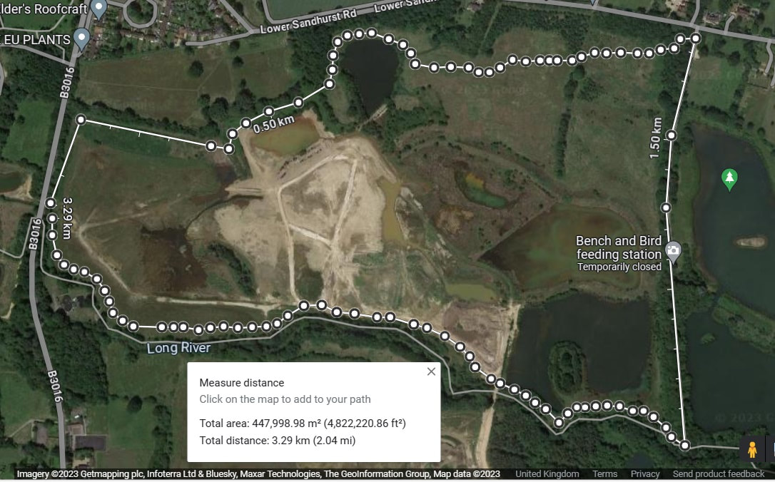 Extent of entire reserve The plan below shows the extent of the reserves. It stretches for 2.2 miles along the Blackwater river. Moor Green Farm is already a nature reserve, namely Moor Green Lakes nature reserve. For more details see here Moor Green Lakes Group or here RSPB entry. The Moor Green Lakes Group may or may not merge with whomever manages Longwater Road Nature Reserve. It is unlikely that the MGLG will manage Longwater Road Nature Reserve as it is just too big for this tiny group. Perhaps you could join us on one of our work parties to aid in the conservation of Moor Green Lakes? Fleet Hill farm is supposed to be ready as a reserve by end of summer 2017. Apart from a few sub-phases, this appears to have been achieved. Approximately 18 months later, Manor Farm will be incorporated into the reserve. A target date in a planning application I read suggested that restoration of Manor farm should be completed by 31st December 2018. Personally, as of 7th October 2018, I can't see this happening unless the scale of infill is altered drastically or a lot more resources are thrown at the restoration effort. At times of writing, it is February 2023. Inert are infilling the current Manor lake, which will take them all of 2023 at the least. You may notice, dear reader, quite a few differences between the various plans and google earth images of the reserve displayed below. I am not sure why. I suspect that some of the differences are due to extraction of gravel. This is certainly true of the Fleet Hill farm portion of the reserve. Note: I have since discovered that the plans for the restoration were fairly fluid and subject to numerous alterations. Update: I am keeping my speculations for historical reasons. Part of the 'fun' of keeping this blog is working out what Cemex and Inert are up to. Well, the later posts show that they are infilling Finch pond. They may also modify Cormorant and Manor farm lakes to look more like the plan. 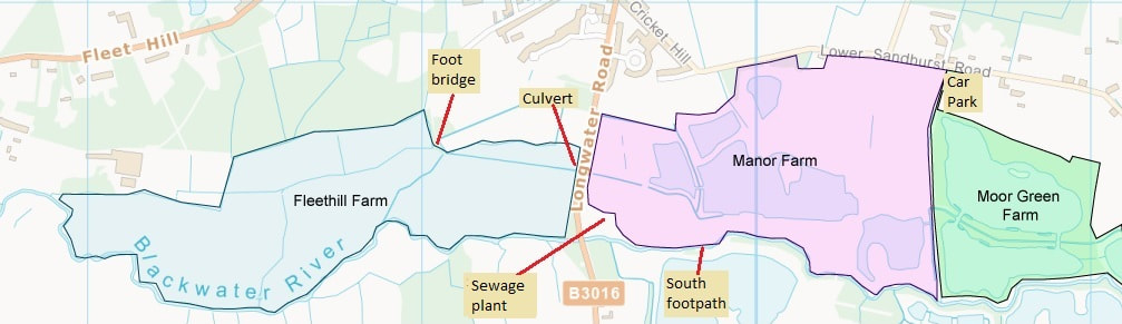 Plan of proposed Manor Farm part of reserve and image from Google Earth NOTE: I've finally got around to updating the google earth image with the expanded reference points. Hopefully, this will allow you to navigate my text a little better. The plan below is the Manor Farm extension. Below that is a Google Earth image as of March 2017. Note the difference between the it and the plan. Particularly Finch Lake, which is now huge, and what I have been calling Cormorant Lake which is supposed to be joined to the bigger lake to its right. The Pump Station area, currently on dry land, would be in the middle of a lake, according to the Cemex plan. As described above we start our walk at the Moor Green Lake car park, located in the top right hand corner of the map. The details shown in this map are the proposed public right of ways, and possibly some further landscaping. As an example, currently there is a sizable lake at the point I call the Pump Station. This lake is not shown in the map. There are large areas of this new reserve I have not photographed as we have tended to keep to the current public footpaths. We cross the Longwater road at the culvert/entrance to the reserve to get enter Fleet Hill farm immediately opposite. Update: February 2023: WBC's Planning website appears to have been updated with revised documents. As we approach the end of landscaping (ground works) I have realised the problems I have had with plans supplied on WBC's planning department website. The draughts person has used the originals, but not updated them correctly. One glaring discrepancy is the double banking between the upper and main reed beds. This is now been built as a single bit of banking. The shape of Finch pond south is not as built, and the plans do not show Finch pond north. The legend is particularly bad in places. Looking at Manor lake, the legend suggests that this will be an area of damp, tussocky, meadow land. However, the colour of the plans would suggest reed beds. This latter assertion is reinforced by the labelling on the plans, which says reedbed! I am singularly unimpressed by the hide on the north end of the peninsular being a proposed hide. Placing a hide and screens here (with views west, north and east) should, in my view, be top priority. The Longwater road nature reserve has been billed as an amenity for Wokingham council residents - not a private reserve for a select few. There should be a balance struck between protecting and nurturing nature, whilst providing mindfulness, viewing and learning opportunities for the council's residents. 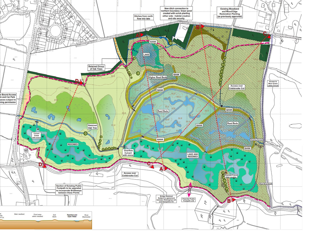 Update: January 2023. This is the proposed rights of way for Manor farm. Horse riders appear to have a very powerful lobby group, and are extracting a great deal of concessions from Cemex. Ver little appears to be being done for pedestrians or cyclists; though the latter will use footpaths and bridlepaths. However, looking at these plans it appears that the existing Blackwater footpath (aka south footpath) will be retained and be separate from the bridlepath that is proposed to run inside Manor farm. I find this very odd, as the horse riders, being so high up, will cause more disturbance for wildlife than pedestrians or cyclists. The bridlepaths around Moor Green Lakes are well screened by trees. Potentially the most exciting path is the one running through the middle of Manor farm. This will give better views of the lakes and reed beds than simply having one path around the perimeter of the site. Unfortunately, it is a permissive footpath, which gives no rights to pedestrians to use it, and use of the footpath can be revoked at any time, without reason. The other odd footpath (again permissive) is the one running around the southeast side of the site. This should give good views over Manor lake - except this vista will be obscured by tall reed beds. Go to Leighton Moss for a good example of this. 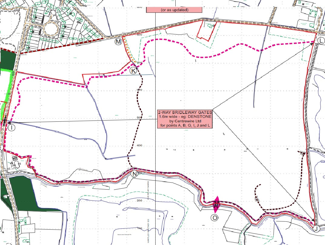 Update: Oct 2022. The plan below is the only one I have been able to find on the Wokingham Borough Council Planning website. It has hardly changed over the years, even though it is billed as being the most up to date. However, as I record the restoration since March 2022, I realise that these plans are approximately accurate. There are a number of differences. 1. Finch pond now consists of two parts: North and South, separated by the Colebrook. The Colebrook now flows in a wide, straight channel - not the wiggly one show in the plans. Also, unless Inert create them in the next few weeks, the small lakes around the new Finch pond do not exist. 2. Copse. To date, the copse still exists. It has not been flattened - fantastic! 3. The final layout of Cricket hill (see second, older plan) appears a little fluid, and does not follow what is in the plans. The boggy area at the south end of Cricket field has been created. However there also appears to be a new boggy area to its north. 4. Higher reed bed only has a bank along its east and south east sides. There is only one bank, not the double bank shown in the plans. The banking along the South east side is shared with the main reed beds. A channel runs along the east bank and south east bank to the south side of the site. 5. The main reed bed banking is still under construction as I type this. The south edge of this bank sort of conforms to that shown in the plan. 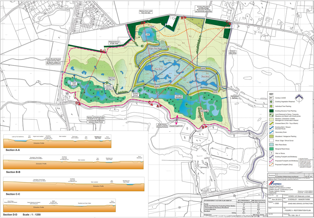 These are the plans for Manor farm which were available when I first started this blog. Whilst the overall structure of the site remains largely static, there are a number of significant changes. The most startling change is that Manor lake will no longer be a large expanse of water. Minor modifications occur with Finch pond (it has got larger, its shape has changed, and it has gained a twin to the north of Colebrook) and the banking around the fens. 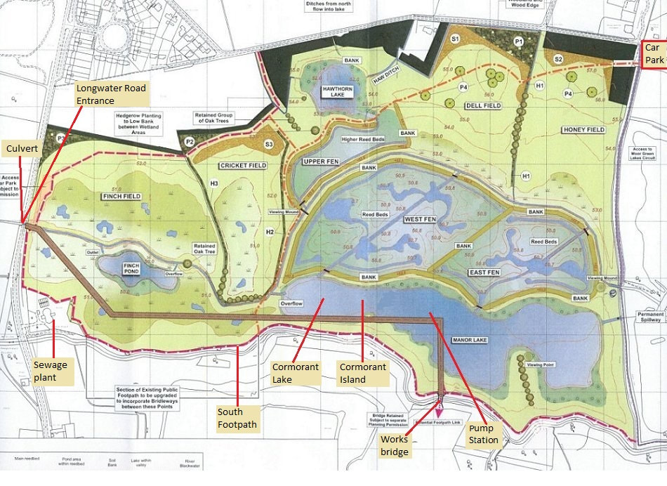 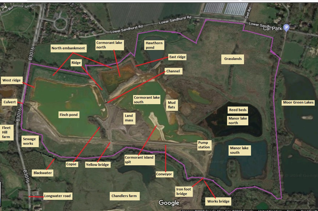 Plan of proposed Fleet Hill farm part of the reserve and image from Google Earth. This is the Fleet Hill farm extension showing proposed structure and public right of ways. Below that is a Google Earth as of Sept 2017. Stone Crusher lake is a small manky green lake. The plans below suggest that it will be filled in. Swan lake is also a small manky green lake, which according to the plan will get bigger. There is a large part of this extension that I have not really photographed as we have tended to stick to the footpaths. Most all the restoration had been completed by the time I started photographing the works. Update: Oct 2022. I have photographed all of Fleet Hill farm and presented them in their own post. Update 7th October 2018. I suspect that apart from a few small pieces of work (e.g. completion of bridle path) Fleet Hill farm is pretty much restored. One of the planning applications I read said that tree planting will occur in the year after restoration has been completed. As this happened earlier on in 2018, this would suggest that, apart from a few sub-phases, restoration is complete. Update: Oct 2022. Fleet Hill farm is pretty much a reserve now. It has been some time since I visited it, as all my efforts have been concentrated on Manor farm restoration. 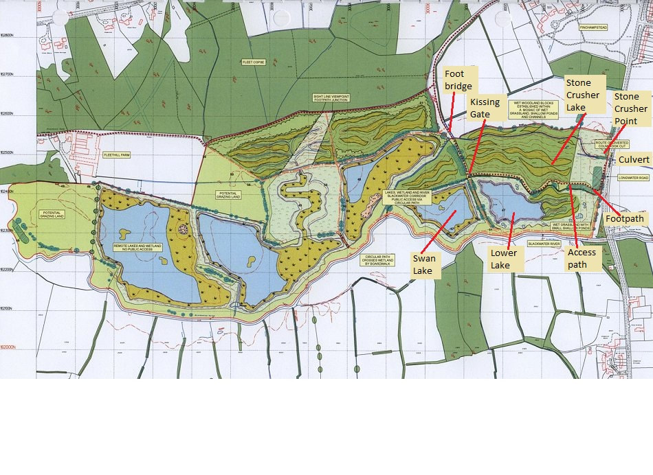 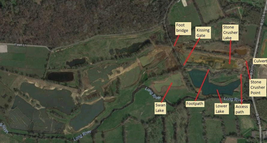 This post shows how the Fleet Hill Farm and Manor Farm parts of the Cemex Eversley gravel works has changed over the years since 1999. Credit has to go to the Google corporation for their Google Earth initiative and also for developing Googe Earth Pro. This free application allowed me to explore a history of the images Google have taken of our planet since 1999, and to also save images. I would recommend you download Google Earth Pro. It allows to you to zoom in to see an incredible amount of detail. As well as showing the evolution of the area, the images also demonstrate the evolution of the techniques Google used to photograph the landscape. If you look closely you will notice that Google had problems stitching some parts of the images together. They also either went through a number companies to do the fly over and photography or simply garnered images from different GIS companies over the years. The images below have been reduced considerably in size from the Google Earth images. It would take ages for this blog to load across the network if I left them at full resolution. Note. I've used Google Earth as was readily available and convenient to use. There are other GIS sources available, which may provide even higher resolution images or greater quality. You pays your money and takes your choice. Several times in this blog I mention the complex geology of the area. I found a map, courtesy of my old College, that goes part way to showing this complexity. Greater detail can be found here Eocene sands and iron map a natty title that sort of rolls of the tongue. I've taken the liberty of inserting a much reduced image in this blog. The vertical red line marks the Longwater road. If you zoom in you may just make out the words "Cemex works" to the left of it. This is actually on the Fleethill farm part of the works. To the immediate right of the red line is Manor farm. Count two large lakes to the right and you reach Moor Green lakes. Quite a landmark are our works. 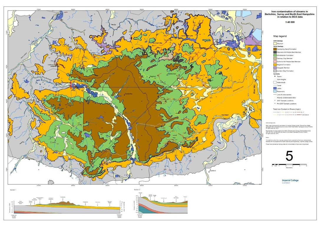 This is now pinned to the top of the posts. I have largely ignored Chandlers farm over the years. Partly as most of the restoration will be (and has been) given over to sports facilities, and partly as it is still an operational quarry. I believe there are some 50,000 tonnes of stuff still to be extracted once the site buildings are demolished. A small area of the site (the north west corner) is to be given over to a nature reserve, and I'm sure I read in one planning document that there was to be a community growing area. Another name for these could be allotments, perhaps. We need more allotments, especially considering the waiting list, and the need to do something to save this planet. I present to you, courtesy of Google Earth Pro (a free app well worth getting hold of) the changing face of Chandlers farm - the original Eversley Quarry. Manor farm and Fleet Hill farm are subsequent extensions to this quarry. I'm deeply suspicious of both the imagery and the dates attached to them. The earlier ones exhibit particular problems, typical of a fledgling service. Imagery has come from various sources, with varying degrees of quality, and they have been stitched together with varying degrees of accuracy. I'd certainly take the imagery dates with a large pinch of salt. The year 'might' be correct, but the date is not always correct e.g. images dated 31st December or 1st January show deciduous trees in full leaf!!! Consider the 'settlement ponds' in the top right hand corner of the site. These three rectangular ponds are, I believe, where water (pumped out of the various ponds and lakes) are passed through to allow sediment to settle out, before the water is put into the Blackwater. The photos for 1999/2000 show these ponds. The ponds are missing from the photos dated 2003, only to reappear in 2004. I hadn't appreciated how much restoration had already taken place on Chandlers farm. Note the football pitches - rather poshly flood lit at night. I thought they had been there before the quarry. But no. They were one of the first parts of the quarry to be restored. You will also notice the stop-start nature of the restoration. Not readily apparent from the large gaps in the imagery data, but quite normal as I have reported in this blog. Still, it looks as if Hampshire county council is putting pressure on Cemex to get Chandlers farm completed, judging by the all out effort put in this year. Alternatively, it might be Inert flitting around the various sites, as we have seen over the past couple of years. However, at least this is being done. Hopefully, the surrounding communities will benefit greatly, and hopefully a small fragment of this planet will be saved for wildlife and future generations. Enough ramblings, on with the show. We've had the wettest February and March on record. Intermixed with all this wet stuff were the odd cold days, and very cold mornings. Surprisingly little frost. Tuesdays, my normal morning for a site visit, were generally either pouring with rain or so overcast as to make not worthwhile visiting Manor farm. To compound matters, California crossroads (double roundabout) are being dug up for some hairbrained, multi-million pound upgrade scheme (which doesn't make sense to us locals) meaning the through road is closed, necessitating a round the houses detour. The first glimpse of good weather, with a warm morning, allowed me to visit Manor farm at 6:30am. I had been worried that in my several weeks hiatus I would have missed much development on Manor farm. You could have knocked me over with a feather when I discovered that absolutely nothing had been done on the site. Nadda, zip, zilch. No fencing, no sluice gates, no bridge near the Longwater road entrance, etc. What have Cemex been playing at? About the only change I noticed was a series of small green, orange and red pennants had been placed along the edge of the bridlepath. No doubts signifying something important, but not obvious to your hard working reporter. I suspect that the flags either signify buried pipe or perhaps changes in fencing. Regardless of their true meaning, I noticed that a couple of flags had come loose, and that there were significantly more pennants on the north bridle path than the south. One explanation for this is that more people have been walking and cycling along the south bridle path and with some of them being local youths, it could be that they have stolen the flags for laughs. What is serious about a lack fencing is that ground nesting birds are in dire trouble. I photographed very fresh dogs tracks this morning on the south bridle path, and some cyclists had decided to go off track and cycle across the site, a few metres where Lapwing and Little Ringed Plovers had bred last year. The other issue I noticed is that the ballast put over drainage pipes, particularly around Hawthorne lake has, as I predicted, begun to erode away - mainly due to the frequent bouts of torrential rain we've experienced. This erosion will get much worse once more pedestrians and horse riders use the reserve. Sigh, what ever happened to British engineering excellence? Too be perfectly honest, I didn't really expect any developments to have occurred during my hiatus. It's pretty much on par for Cemex. I have spent the past few weeks: building an Ark as it has been raining so much (apparently the wettest February in 268 year), trying to stay warm in the occasional cold snap, but mainly decorating our downstairs. I didn't feel too guilty about not making site visits, as I reckoned Inert would not have returned. Sure enough, Inert (or any other contractor) have returned to Manor or Chandlers farm since last year. Chandlers farm still resembles a bomb site, with the rock sorter outer perched on a huge pile of stuff where it was left last year. Manor farm is the same, possibly settling a bit, green shoots beginning to appear, and still flooded on it south west corner. I bumped into a couple of regulars who say they heard that work to complete the site will begin imminently. I'll believe it when I see it. Lots of people have been walking on the bridle paths, I would say the southern one more than the northern one. Probably because the fence has fallen down along large sections of the bridlepath. Well, fencing with wire mesh will be needed pdq as the breeding season is upon us. Here are some photos of a Buzzard I spied opposite the MGLG car park as I was putting my wellies on. A belated happy new year in what could be an auspicious year for Manor farm and the Longwater road nature reserve. Both may actually be opened officially as Cemex, Inert and contractors complete restoration work. Naturally, there will be fettling and other small pieces of work, but the installation of fencing, crossing over the Colebrook by the Longwater road entrance, and sluice gates should allow the reserve to be open to the public. One immediate piece of fettling that needs to be done pdq, is the flooding of the south bridlepath just north of the sewage works. I've been warning, for some time now, that this portion of the bridlepath will be under water during the winter months. Sure enough, as with last year and previous years, this whole area (including the Blackwater valley footpath) is under up to six inches of water. Note, water levels would have receded a fair amount due an unusual period of dryness - indeed, we witnessed this on the footpaths we traverse during our morning walks. I photographed the bridlepath yesterday (Tuesday) when I returned to Manor farm since 16th November 2023. During my hiatus, the weather has been particularly bad; either horribly overcast, raining or, in many instances, both. The Christmas period was very wet, with torrential rain falling on saturated ground, thus causing flooding. Note, however, that the area north of the sewage works floods regularly every year. It takes a particularly dry autumn and winter for it not to flood. I reckon that remedial work will require drainage pipes to be installed under the bridlepath, the height of the bridlepath needs to be raised by at least 12 inches (30cm), and the area (including the Blackwater valley footpath) drained properly into the Blackwater river. These actions need to be repeated along various sections of the bridlepath between the grey box and sewage works. I have photographed bits along this section that flooded earlier in the autumn. Otherwise, what of Manor farm in general. Well, firstly it should come as no surprise that Inert have not returned to Manor farm or Chandlers farm. All is as was before work ceased last year. Secondly, the water levels in Manor lake, Finch pond and the reed beds are high, but do not look high; partly due to banking and partly due to run off into Fleet Hill farm - I didn't venture here to check on flooding. Sadly, the depth of water in the lakes and reed beds are still low compared the once mighty status of Manor lake, Cormorant lake and Finch pond. Thirdly, vegetation has taken hold over much of the recent workings, giving the area a softer, 'lived in' look. After a manic week and a bit of family events, life returns to the medium slow lane. I didn't pay my normal Tuesday visit to Manor farm as it was very cloudy and then poured with rain. The mild, exceedingly wet weather persists. Wednesday, however, was bright, clear and cloudless. Wonderful for photographing birds...only they were somewhat sparse on the ground. The Blackwater was bank full in places, possibly flooding in others - most notably sections of Fleet Hill farm (unless the banks have been shored up) - with plenty of standing water over the restoration. I reckon conditions on the recently restored areas will be lethally soft. As you would expect, not much, if anything, has happened since the start of my short hiatus. The idea to to let the ground settle down and consolidate. Having one deluge after another 'may' assist this process slightly, as huge rain drops beat on the ground. Manor farm was as I left it, two weeks ago. Chandlers farm was eerily quiet - and I doubt it had anything to do with it being a tea break. Not a piece of heavy plant in sight or clank of machinery to be heard. Only the spider armed boulder crushers upper was to be seen, lurking silently on a hill of spoil Water levels in Manor lake were not very high, despite all the rain and named storms of late. I feel there is a crucial sluice gate missing, one that was on the original plans, namely along the straight channel leading to the culvert under the Longwater road. A sluice gate is needed here to control the flow of water out of Manor farm in a westward direction. I suspect that MGLG members have set about building a fence of brash and branches to stop access to the north bridlepath. It should stop all but the most determined of walkers, but there were a couple of points in the fence where very easy access is possible with minimal effort. The fence needs more branches. Unfortunately, this effort is very much like barricading the front door of a castle, whilst leaving a back door wide open. Along the eastern side of the south bridlepath, large sections of fencing have collapsed, allowing walkers, dogs and horses to simply step onto said path. The two sluice gates have not yet been fitted. Strange that, considering Inert were rearing to get on with the west sluice gate way back in June. One worry with this break in work is that if it is left too long and work doesn't recommence until next year, then we are in danger of yet more postponements as construction stretches into the breeding season. Though I do ask whether efforts will be made to provide plenty of pebbly ground for Little Ringed Plovers to breed? Needless to say, updates will be sporadic over the next few months. At the risk of incurring the wrath of SWMBO, I thought I'd sneak in this update before family events begin.
I've heard that the opening date of the Manor farm part of the ex Cemex quarry restoration has been pushed back to summer 2024. A slippage in dates for a major project such as this is not unusual, disappointing, but quite normal. Many tasks remain to be started, yet alone completed. Fencing the area, for instance, will take quite sometime; and this task cannot really start until the bridlepaths are completed. A number of snags to the path need to be fixed e.g. flooded parts north of the sewage works for one, crossing over the Colebrook for another. Further fettling of Manor lake might be required after the surveyors were in last week. Add to all this, reduced day light hours, lousy weather and the fast approach of Christmas, and it is apparent that this restoration will not be finished this year. Another reason for pushing back the opening date, which I completely agree with, is it allows time for the ground to settle and consolidate. A lot of the newly landscaped ground is, as I've often harped on about, lethally soft, with the consistency of quicksand - as my muddy wellingtons up to my knees can testify. And while most of the bridlepath is now quite firm, a few extra months will help the ballast it is made of to pack down solidly. Right, I have to go off and be nice to people. See y'all in a couple of weeks; as all social media devices may be confiscated for the duration. Firstly, dear reader, a heads up. I will not be updating this blog until 14th November at the earliest - ironically the day the MGLG car park will be closed, making parking tricky. We have rather a lot going on for the next week or so. Usual stuff: birthdays, anniversaries, odd day out, etc. Avid readers will be devastated with this news; at a complete lose what to do with themselves, except sit and stare at a blank wall for hours on end. Chin up, it's only two weeks. Storm Ciarán approaches, with high winds and lots of rain predicted Wednesday and Thursday in particular. I reckon the section of bridlepath north of the sewage works will be totally covered in water. Even with so much rain of late, water levels in Manor lake are really quite low. Lots of open water will be hidden by the raised soil levels. More so if reed planting and other vegetation take hold. Great for wild life, I suppose. Reasonably rubbish for seeing the birds. It was like this at Leighton Moss, with its reed banks. Heard lots, couldn't see a thing. A small, teeny, weeny digger had been working at the volcano shaped ballast pile by the Bailey bridge. It has been spreading the stuff around the north end of the Bailey bridge, joining the east and west sections of the south Bailey bridge to each other, and to the Bailey bridge itself. This sort of confirms that groundworks are complete. But wait, there's more! As they say on American adverts. Firstly, the two sluice gates need to be installed. Secondly, there will be more fettling. One hopes that the heavy plant, trundling across the site to perform these tasks, will not destroy the freshly laid gravel paths. Usual brilliant planning. I have mentioned this before, but installing the sluice gates, particularly the east one, will (I reckon) be tricky. For why? The ground is very soft to quicksand in nature as a result of heavy rain and the actions of bulldozing and smoothing with diggers. Construction personnel beware. Other than that, not much else has happened since my early Sunday stomp. Though a fellow MGLG member, oft stomping the site's boundaries, did say that he saw a hive of activity last Friday. Four diggers at work landscaping, and surveyors with their natty laser theodolites checking said landscaping; I assume. As predicted, idiots have been ignoring the keep out signs and walking onto the north bridlepath. This morning, a horse rider was spotted cantering along the south bridle path from Moor Green Lakes nature reserve to the Bailey bridge. Only the rider turned round and headed back east along the bridlepath, probably after spotting the digger at work around the Bailey bridge. I did say this would happen without fencing. I am hoping that fencing will be in place when I can next return to the area. You know when not much is happening when I post more wildlife photos than construction ones. With the clocks going back an hour, I was able to get to Manor farm restoration at 6:30am this morning. Reasonably bright. Not a great sunrise. The bridle path crossing over the Colebrook prior to it going under the Longwater road not yet built. A section of bridlepath just north of sewage works was almost entirely under water; and this after a few hours where levels could fall a little. During really heavy rainy periods, the flooding can increase by a further 5-10cm (2-4 inches) of water and remain for weeks. At which point this section of bridlepath will be completely under water. Minor flooding of bridlepath occurred from sewage works to bailey bridge. Wow, Inert appear to have completed groundworks north of the Bailey bridge where gravel excavations took place. The area is unrecognisable; deep channels, almost chasm like, weaving in bold curves and sweeps like a Henry Moore bronze sculpture. Shame water levels in them wont be very deep. The whole area does look impressive, though. I didn't walk over the recent landscaping, even in my wellingtons. I know only too well that areas will have the consistency of quicksand, and I'll sink up to my knees in the stuff. I did try venturing out a little, towards what will be the east sluice gate, but gave up within 10 metres as I struck squidgy bits, with my wellington boot disappearing into mud without much pressure being applied. As predicted, I could not walk onto the east side of Manor lake (basically the old Manor Lake east of the Bailey bridge) due to channels and moats being built around it. I did try to cross a bit nearest the south footpath, where a channel was no wider than a narrow stream, but quickly abandoned that idea as my wellington started to sink rather deeply into the stream bed. Also, I figured the newly bulldozed ground on what was Manor lake would be very squidgy. Not going to risk sinking up to my knees in the stuff again. There was an awful lot of bird life on the restoration. Loads of Green Sandpipers, and other birds I only caught glimpses of. Our resident Kestrel was about in the low light of early morning. While a couple of Red Kites flew lazily around - a lot of effort with no thermals. Otherwise, the usual birds were around, in large number. Photos to follow as and when. Painting staircase almost finished - the thing, as built, by builders is appalling. Loads of basic schoolboy errors. Much fettling on my part, armed with wood filler. Photos to follow. |
AuthorA polite notice first: All photographs on this blog are owned by me and subject to copyright. Archives
November 2025
Categories |
 RSS Feed