Deep hole being dug in odd place. Dinky earth mover dumps ballast into bridle path. 29th August 202329/8/2023
A very grey, overcast morning. Not good for photography. All the gulls and terns have gone. Tern island very bereft of birds. Fairly quite on Colebrook lake (north), pretty similar for Manor farm. Inert have changed to a much lower gear, restoration wise on Manor farm. A lot of effort on Chandlers farm. A digger operator was digging a very deep hole in a very odd place: just east of the hole for the east sluice gate. I really can't work out why this hold is being dug where it is being dug. Inert went to a lot of effort to fill in this part of Manor lake. However, this does seem standard practice for Inert. Fill in a place, smooth it over, then dig it out again. The digger was bringing up blue-grey soil. It normally forms in anaerobic conditions; which could mean deep under a lake e.g. Manor lake. Quite baffled as to why the hole is so deep. Except it might be for gravel extraction. Shame Inert infilled the lakes around this area. I saw the smallest earth mover I have ever seen on the site, trundling its way, quite dinkyly, eastward along the bridle path trench. It went over to the digger operator to take him to Chandlers farm for a tea break. The earth mover had dumped three loads of, what looked like, ballast on the bridle path trench, immediately south of the Colebrook channel, which heads under the Longwater road. It looks as if Inert are cracking on with constructing the bridle path, and not leaving for some other time in the future, by which time the trench will be over grown. Two odd points about the process. Firstly, I could have sworn a weed proof, permeable membrane should have been laid in the bottom and sides of the trench. I couldn't see one. Secondly, the stuff being dumped looked like heavy duty ballast, not gravel. It sort of makes sense. When I build patios, I put down a decent foundation of ballast, and any hardcore I can lay may hands on. Actually, I need 22 yards (tons) of soil. Seriously, to fill in a ditch. I wonder if Inert have 22 tons spare, and would they deliver in five four ton loads and one 2 ton? We have a nice wide, deep driveway. Gives me time to shovel into ditch if loads come every other day. :-) :-) :-) It just occurred to me, as I was processing this week's photos, that the area at the corner of the sewage works and Longwater road is still very low lying and prone to flooding. I'm not sure if this area has had a capping layer of soil to build up its level. It has been some time since Inert worked on this area. This is where the bridle path goes! This means the path could get water logged, which in turn means it will deteriorate quickly. In fact, the footpath alongside the sewage works and the Longwater road entrance is notorious for flooding. The section that runs alongside the Longwater road is particularly bad, supporting a 'puddle' over six inches deep (deeper than much of Manor lake!!) and extends for over 15m; it was much loved by a Moorhen earlier in the year. A lady dog walker, I saw earlier in the year, couldn't take her two Dachshunds along the path because they would have to swim through the puddle as it was so deep. First off, that awful 45th US president got banged to rights on Thursday. In an historic first, he had a mugshot taken. Unfortunately, I had to see his ghastly orange face, leering at me from BBC news online front page. Secondly, I will not put your through the ordeal of viewing over a hundred photos. I'm relieved as well. It takes a considerable time to process them. Today's photos are hampered by lack of light. Sunrise was 6:06am. It generally doesn't get properly light until about 20 to 30 minutes after sunrise, and only then when the sun has cleared tree lines. I got stomping from the Longwater road entrance at 6:00am. Overhead was thick cloud and mist! Thirdly, I got it wrong with the north gate to the Bailey bridge. I forgot that it had been replaced, and was now a single gate, and that I had to walk across the access road, over to the hinge side to climb over it. You have to cut me some slack, I am still quite dozy at 5.00am to 7.00am on a weekend morning. What fooled me was that both sets of gates were unlocked, and open. I closed the ones on the Chandlers ford side of the bridge, as they were easy to secure. Yes, the Yellow pump is back, sat near the Bailey bridge, along with short lengths of pipe. I am somewhat perplexed by its return. The only reason I can see for it is to pump out water from the excavations to the immediate north of the Bailey bridge, where gravel is going to be extracted for bridle and foot paths. Seems like a lack of planning, going on here. a) Why was our old faithful red pump removed? It didn't seem clapped out, and was going strong, if a little noisily. The new pump costs money to hire. I think the old one belonged to Inert. b) Where is the water going to be pumped? I don't think it can go directly into the Blackwater. It can't go over to the settlement ponds in Chandlers farm because, guess what, the pipes leading to them across the Blackwater have been removed. The only place left, from what I can see, is Manor lake. But guess what, the sediment from pumping will settle into any deep bits of water, lowering the depth of water. On to the south bridlepath. The section from the Longwater road entrance to about 50m east of the sewage works has been scraped smoothed. I'm not sure if this was done by a bulldozer or digger. I suspect former. Overall, the path is very firm underfoot, but there are numerous soft spots. This will cause sinkage in the top covering, which in turn will cause an uneven surface for users. Inert carried on digging the trench where they left off last week, about 50 yards east of sewage works, through to about 50 yards west of the Bailey bridge. The bit between near the sewage works and where the path hits the old south (limestone) vehicle track still needs smoothing off. Whereas at the Bailey bridge end, the path sort of peters out. A quick eyeballing give the distinct impression that the land surface here, were the path peters out, is about a metre higher than the Blackwater footpath. I can't really see what else Inert did since Tuesday. Yes, they have spread more capping soil on the ground between the bridlepath and the Blackwater valley footpath. They may have done a little tinkering here and there, but nothing obvious. The bridlepath to the east of the Bailey bridge appears untouched, but I didn't bother going down there. I certainly didn't visit the north bridle and foot paths. I doubted anything would have been done on them. I'll attempt to look on Tuesday, but probably only if Inert have cleared the path to the Moor Green Lakes Group car park. So far the weather is looking dry. And I carry my Hi-Vis vest with me, to stand out, just in case any one is working on the site. Which I stay off if I know they are there. The north edge of the south bridle path is up to 25m closer to Manor lake than the north edge of the Blackwater valley (aka South) footpath. Quite a lot is 7m, with it being 15m closer at the famous Grey box. For me, a photographer primarily, it brings me much closer to the birds. For birders, it offers greater scope for seeing birds. Sadly it might mean birds, particularly on Manor lake, may move further away into the Main Reed beds. However, thinking about this. The footpaths and causeways we walked along at RSPB Leighton Moss were as close if not closer to open water as on Manor farm. However, the area was covered in reeds, which towered above our heads. We couldn't see anything. Birds were quite happily hiding in the reeds, probably quite close to us, but quite obscured. Great for the birds, less so for birders and photographers. But then again, the Longwater road nature reserve is for wildlife, primarily, though as a community resource, a balance has to be struck between providing views of nature, without causing too much disturbance for said nature. Now, I forgot that bridle paths (or Bridleways) are open to foot, pedal cycle and horse traffic. This means that birders, in particular, will gleefully walk along. And it is lovely and wide. Originally against it being a bridlepath, as I thought it for horse riders, and having had a couple of nasty encounters with rude, entitled horse riders arrogantly forcing me off footpaths (note, footpaths; where they shouldn't have been) I was against them. However, thinking matters through. They could be very good for wildlife, if joggers, casual walkers and dog walkers can be kept to the Blackwater valley footpath. They tend to be the most disruptive to wildlife, especially day trippers from Horseshoe lake. Horse riders tend to be quite rare (so far), hence cause a small amount of disruption to wildlife. Cyclists are generally quite, but tend to whoosh past, again causing little disruption. Hopefully, that leaves birders and walkers to use the bridle paths. These tend to be very quite and respectful of the countryside and wildlife. Even now, there are a surprising number of people using the footpaths who are, shall we say, nature watchers, out to appreciate the country side. Unlike last week, the going on the site was firm due a spell of relatively dry and warm weather. I didn't need wellingtons. Wildfowl were in reasonable abundance. The usual Egyptian geese, Canada geese abounded; joined by Lapwing, Green Sandpipers, at least eight Little White Egrets, the odd Cormorant, and the normal Mallards. I didn't pay too much attention, plus it was early and the birds hadn't got warmed up. Of the Marsh Harrier, Kestrels and Hobby, there was no sign. Again, it was very early, and there was mist or low clouds grazing the tops of trees. Photos to follow, after the Memsahib and I get back from our morning constitutional around local footpaths. Update on 26th August. I had this niggly feeling that I was missing a photo from my stomp around the north bridle path. Indeed I had, as I 'discovered' it this week on my cheapo, ancient compact digital camera. It was a photograph of the eastern end of the cleared route of the path. I met a Cemex staff member who visited Manor farm restoration to check up on restoration and the route of the bridle/foot paths in particular. An Inert manager was with her to. They explained that a whole load of gravel will be dug out just north of the Bailey bridge and used to create said bridle and foot paths. The resulting hole will be filled in with material forming Crescent bank. I have seen plans for the site where there is mention of digging up gravel from just north of the Bailey bridge for creating paths. So that is consistent. Anyway, Inert were at work, digging out the western portion of the south bridle path, basically following the route of the former south vehicle track. The spoil from the resulting trench is being dumped on top of Crescent bank. There's an awful lot of it, which will make a very deep, big hole. One aspect of the bridlepaths and footpaths that did surprise me, was how close they are to areas of open water i.e. Manor lake extension and Hawthorn lake. Whilst brilliant for birders and us photographers, it's bad news for wildfowl, as they would be frightened off by people being so close. And as for horse riders, being some 8 feet or more high in the air. I will have to wander over to Fleet Hill farm and see how wildfowl cope with the bridlepath that runs around what I call south lake i.e. the lake to the south of the Longwater road entrance. There were some birds who weren't too bothered. I can't remember if the Great Crested Grebes were still in the lake. As you read this update, please be aware that I have plans from WBC planning that contradict each other. One set has a bridlepath running all around the north part of Manor farm restoration. Another has a bridlepath only going part way round from the Longwater road entrance to roughly the middle of the north edge, where it turns north to follow an old farm track to the Lower Sandhurst road. What continues to the Moor Green Lakes Group car park is a footpath only. This latter plan makes more sense to me. Anyway, on with another marathon photo fest of the route of the north path I photographed on Sunday after my tip off from a Finchampstead Parish councilor. It was strange photographing with loads of light and no sunrise. I've decided to tag my Tuesday stomp report on to the end of this posting as they are sort of related. The Cemex representative was visiting Manor farm restoration to inspect progress, primarily of the bridle and foot paths. She was driven around the site by an Inert manager in a new shape Landrover Defender. I'm still in two minds about the new Defender. I love the old Defender, but the new one doesn't quite float my boat, as they say. It is too smoothed off and like the plethora of bubble cars. It is sort of distinguishable from the generic SUV, but only if you pay attention. Some of the colour schemes I've seen on them are positively ghastly. The Defender did very well, coping with the very, very uneven surface of Dell and Honey fields, also crossing some of the more boggy ground. Though they didn't cross over the very boggy ground that was the ridge. Apparently, I am known to Cemex, and she asked walkers who talked to her if they were Angus. Gulp! I had visions of being carted off to the clink (handcuffed and slung in the back of the Defender) or being issued with writs for all the pithy comments I've made in my blog. Nah, nothing of it. We had a very pleasant chat, when we met. She was particularly excited about our resident Marsh Harrier - and who wouldn't be. Anyway, enough name dropping, idle gossip. One with Inert's latest progress. The pace of which is exhausting. They are completing in days jobs that used to take them months. A digger has continued digging the west bridlepath trench on the south side of Manor farm from where they left off on Friday. A truly substantial trench it is. The spoil from the trench is being dumped on Crescent bank, and will be used to infill a large hole Inert will dig to extract gravel for the various paths they are building. I was very surprised how close the paths were to Manor and Hawthorn lakes. A lot of wildfowl will scurry off when people and horse riders come by. However, they will return at dusk when they learn that people do not appear. My very early morning forays onto Manor and Fleet Hill farms reveal plenty of birds. Some pretty substantial fencing needs to be erected pdq. Said fencing needs mesh along it to stop dogs from getting onto the reserve and frightening off birds - particularly ground nesting e.g. Sky larks and LRPs, if the latter ever come back. LRPs need lots of shingle and gravel surfaces to nest on. I'm not sure if the design of the site accommodates this covering. The Cemex representative did mention that they were thinking of putting a car park on Fleet Hill farm. We know that the Longwater road entrances to Fleet Hill farm are a very popular spot for parking cars. The only issue is sight line for drivers, as this section of road is still, perversely, 60mph! Though to be honest, most drivers only get up to 40mph. I have seen, in a planning document, a statement saying that the speed limit will be changed to 30 mph, once the reserve becomes operational - open, in layman's terms. Actually, I feel 40mph will be more suitable. Words with local councils could speed up (no pun intended) the speed limit being lowered. Most all residents would be very pleased for this to occur. Oh, I do hope that more than 20 spaces will be provided. This is a figure I've seen on a site diagram for a proposed car park on Manor farm at the Longwater road entrance. Whilst we were stood chatting on the Bailey bridge, the Inert manager suggested lowering the footpath there by a metre or so. I'm not sure how that is going to work with the Bailey bridge. One plan by Finchampstead Parish Council is that the Bailey bridge would offer good site access for vehicles via Chandlers farm. It ain't going to work if there is a couple of feet or three drop on the north end of the Bailey bridge. Oh, one huge surprise to me, which I didn't pick up on. There is a foot bridge on the east of the Bailey bridge. This used to carry the outflow pipe from the pump, and was obscured by vegetation. Now that the vegetation has been cleared, and the pipe removed, the foot bridge can be seen. It needs a bit (fair bit) of work to bring it up to scratch. Can't see the point, really. The Bailey bridge is good enough. Anyway, enough waffle, on with progress slideshow. Prepping for bridlepath. Further landscaping of east part of Manor lake extension. 19th August 202320/8/2023
English ladies footpath team make it to the world cup final, to be played against Spain. Sadly, I have just discovered, whilst updating this blog entry, that the valiant ladies lost 1:0 to Spain. A wonderful effort, nevertheless. Stop press! I talked to a Finchampstead Parish councilor at a Finchampstead Development Plan roadshow, and he told me that contractors had been around the top of Manor farm restoration cutting a 4m wide 'path' through the grasslands up there. Your intrepid reporter couldn't resist this opportunity to record what has been done. My first surprise was not finding the start of this 4m path near the Moor Green Lakes car park. Even after walking about 100m south towards the river Blackwater was no path to be discovered. I marched back to close to the MGLG car park, and took off westward into the north part of Manor farm. Breaking out of the wooded part of this site, I happened on a vast patch of nettles, thistles and small brambles. Now, at this time of the year, nettles are maturing to a semi-hardwood status. This gives nettles spikes the ability to pierce my walking trousers. It was painful going, fighting my way southward and westward through the nettles, whose stings were aided and abetted by thistle and bramble spikes. I finally reached grassland, and struck out westward. Still no sign of the wide path. Eventually I reached a fragment of hedgerow, and a path of short, mown grass. Interesting! I struck out south, towards the main reed beds, but saw nothing. I retraced my steps, and noticed two features. To the north, was a gate at the head of a short track, leading from where Dell Road intersects the Lower Sandhurst road - civilisation! I then noticed the 4m wide path, heading off westward. This swathe of mown grass more or less hugs the north of the site (at slight odds with the plans I have), but rather excitingly goes right along the north shore of Hawthorn lake. Additionally, walkers are about 8 feet above the lake, giving superb views, but frightening any wild fowl on the lake. Looking at the final plans carefully, I've discovered that this section of path is for foot traffic only. This is superb news, as horse riders, being so high up, would definitely scare birds away. As it is, they are very nervous of walkers. The path snakes around the north part of Manor farm, around what was Cormorant lake (north) before terminating at its southwest corner. The path does not continue around what was the mighty Finch pond, to fetch up by the Longwater road entrance. This explains why I didn't know about this path as there was nothing to see on my early morning Saturday site visit. Oh, I spotted a Hobby, Kestrel, Buzzard (I think, though it might have been the Marsh Harrier), Barn owl and a Grey Heron. Inert need to get a really decent, dog proof fence erected along the entire length of any type of paths. Perhaps the most exciting development this week: Inert start work on the bridlepath and footpath that is allegedly to circle the Manor farm restoration. On the west side of the site (Bailey bridge to Longwater road) a digger has been cutting a wide shallow trench, that follows the route of the Blackwater valley footpath. Westward, the bridlepath stops at the Colebrook as it disappears under the Longwater road. A bridge will be required to get across the Colebrook. As the bridlepath heads east, the trench sort of fizzles out when it reaches the recent landscaping, starting at the hole for the west sluice gate. On the east side of the site (Bailey bridge to footpath from Moor Green Lake Group car park to River Blackwater) Inert have simply mown down all the nettles and weeds along the route of the Bridlepath cut by contractors some months ago. I guess the digger will go over this cleared path at some point to cut a shallow trench. In clearing weeds and nettles, Inert have knocked down fencing here and there. The fencing man needs to get to work, pdq, to erect proper, robust fencing. I think the basic method of creating a bridlepath is to first cover bottom of trench with weed proof material, Then cover with scalpings and/or gravel to required depth. Landscaping on the east part of the channel has been completed. There is just the middle bit (around Crescent bank) to be completed, thus joining Manor lake to its extension. The infill of what was the last remaining fragment of Cormorant lake has not been as aggressive as feared, and there is some wide expanse of open water. Rather grimly, Inert appear to have made inroads into the wooded area just west of the Bailey bridge. Ominous piles of soil have appeared, some of which have been placed in some grassy patches of the wooded area. I do fear this established and beautiful area may be sacrificed to the infill god. Well, it looks like we're entering the end game for restoration of Manor farm. Hopefully, by close of year the newest reserve in the country, Longwater Road, will be opened officially. As usual, photo updates will occur over the coming week.
A further quick update. The diagram below shows where Inert have cut a swathe through grassland to mark out both a bridlepath and a footpath along the north of Manor farm. 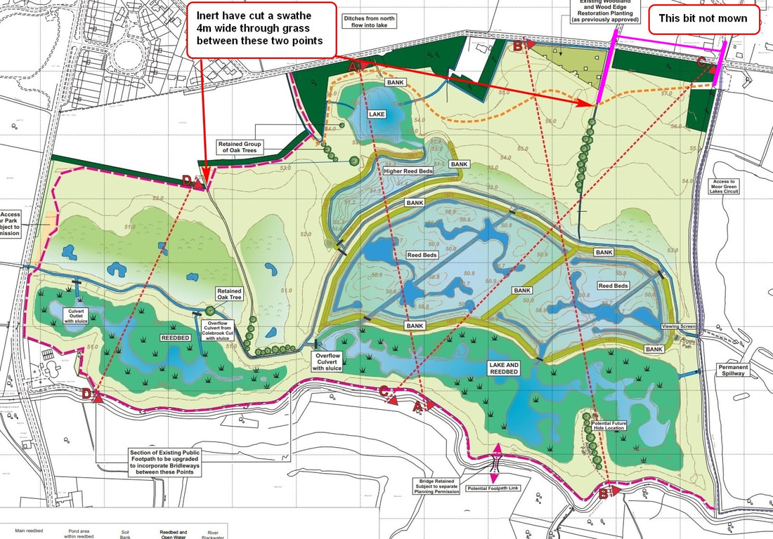 This weekend's foray on to Manor farm restoration saw me well prepared with wellingtons. Partly as I was determined to get to the north side of Manor lake extension, and partly as we had a lot of rain during the week, especially on Friday - yesterday. The surface mud, where Inert had been landscaping, was a particularly nasty type that clung to one's boots. It is very easy to get a kilo of mud or more on each boot! There were parts of the restoration, where Inert had been working, where I didn't dare traverse, even with wellingtons. My foot would start sinking into the mud, even with light pressure. One particular section, northeast corner of Manor lake extension, against the banking, consists of bit of remaining mudflats from the old Cormorant lake (south). This mud is particularly lethal, being deep and the consistency of quicksand. Anyway, I was able to cross over to the north shore of Manor lake extension near to the west sluice gate hole. Getting to the south shore, via the east side of Manor lake, was a more difficult proposition. Inert had been working there, and I learned from bitter experience that this would mean very, very soft, 'sink up to your knees' mud. This next tranche of photos covers the north side of Manor lake extension, which I wasn't able to fully traverse last week due to lack of wellingtons. As usual, I have taken a lot of photos, as the structure of the landscaping will not be seen once covered in vegetation. Now for a little light relief from tedious photographs of mud, mud and yet more mud. Some dragonflies and demoiselles I photographed last week. Some were on Colebrook lake (north), Moor Green Lakes nature reserve. Some (not in water) were on Manor farm restoration, next to Blackwater valley footpath. This next tranche of photos takes in the middle bit of un-landscaped area between Manor lake and its extension. Once landscaped we should get one long Manor lake. Though it is more of a mire than a lake, hence why I call it Manor Mire. I also take you along the cleared route of the south bridlepath. Although I took loads of photos of this path for historical context, I have spared you, dear reader, from having to endure viewing endless photos of seemingly identical looking bits of grass path. The ones I took earlier in the year will suffice. We also visit the area immediately to the west of the Bailey bridge. This has been cleared by Inert (particularly the pump pipes) and landscaped. I fear for the established wooded and reed area, as many piles of soil have appeared to the west of it, some encroaching on its western edge. I should really get down to Manor farm restoration everyday, such is the pace of activity. Since my very early morning Saturday visit, Inert and/or contractors have: Planted reeds around shore of Manor lake extension's channel (deeper, wider bit). I can't tell if the reeds are truly planted or simply plonked on top of the banks and then given a thin covering of soil. Problem is, we are entering a warm period, with temperatures expected to exceed 25 C, possibly hitting 30 C, for two weeks or more. These reeds may die if either water levels are not increased or they are watered almost every day. That's the biggest problem I've seen with restoration, lack of post planting care; particularly of saplings. Fleet Hill farm saw 30%-50% of saplings die in the first year they were planted - mainly because there was a heat wave a week or two after they were planted. Nobody went around with a water bowser to water the saplings. A digger operator was busy at work around the east sluice gate hole. He appeared to be digging a channel or at least extending the one on Manor lake towards the extension. I did say Inert would have to dig out a whole load of ground to create the necessary deeper bits. There was a huge pile of spoil piled up against the northeast edge of Crescent bank. Talking of Crescent bank. I reckon it would make a fabulous site for 340 degree viewing screens and possibly a hide. Access would be via the Bailey bridge and Blackwater footpath. The 20 degrees of non-viewable area simply points back to the Bailey bridge. I've often talked about how one gets a totally different perspective on a reserve by being about 15 feet high. I got superb views when I stomped along the north embankment - before it was demolished. The east part of the north embankment was the best, as it was about 30 feet high. Anyway, Inert have smoothed the west side of Crescent bank or mound. This indicates that this odd feature will remain. Apart from being a great place for an almost all round viewing screen, I can't fathom what else it is for. I have a feeling that Inert have also been fiddling with the channel, certainly near the western sluice gate hole. It looks a bit more worked, since Saturday. One place I could really discern was the last remaining fragment of Cormorant lake (south) where the pump pipe pontoon used to reside. The area looks as if it has been smoothed down, without wholesale infilling. I also think the rough area on the southeast corner of Manor lake extension has also been smoothed down. A maxi digger was at work alongside the south footpath, about 50 yards west of the Bailey bridge. It appeared to have dug up several large concrete blocks, and appeared to be working its way eastward to along the established wooded and reed area next to the Bailey bridge. I do hope this area is not razed. Finally, an orange digger was at work on Chandlers farm. It appeared to be digging up the pipes from the pump station leading to the settlement ponds. Inert sculpt western half of Manor lake extension. Tremendous amount of work. 12th August 202313/8/2023
This week's format follows that of last week. An initial posting, followed by a number of photo updates due to the large number of photographs I took. But first, a really good place to plonk a hide and viewing screen might be where the 'Grey box' is situated. This grey box (a transformer) is a well known landmark, and is used to direct bird watchers. I've also realised that it gives decent views over the banking separating Manor lake (mire/marsh) from the main reed beds, as the banking is actually quite low here; it's basically the bit Inert plugged. One big issue is how tall will the reeds grow? If the really tall variety, like at RSPB Leighton moss, then little will be seen of the main reed beds. If a shorter variety is used, then more will be seen of open water areas of the main reed beds - unless the intention the entire area is covered in reeds. A great shame if so. It aint 'arf boring, and not much of a community asset if people can't see anything. Note: Longwater road nature reserve was/is considered a community asset - and should be managed as such: to promote wildlife, educating people of said wildlife and conservation, and providing a green landscape for people to enjoy. I hope the grey box is retained. Though taking out its innards would be a good idea, and also making it obvious this has been done. Otherwise some thieving oik will try and steal the wires inside. A point I've made before: unless effort is made to provide an extensive stretch of pebbly/gravelly ground, the Little Ringed Plovers will no longer breed here. Which is a shame, as they do so well. Unfortunately, I noticed that Inert had scraped a great deal of the gravel and pebbles that used to cover the site from the yellow bridge eastward to almost the Bailey bridge. It was obvious from my Tuesday visit that Inert were now working on sculpting the Manor lake extension, finally. What remained to be seen was whether they would stick to their task or would this be an example of them flitting about from place to place; starting one job, working on it a bit, but taking months to complete it as they flit off to another task. I had to lift my jaw off the ground when I arrived on Saturday morning. Inert had completed a huge amount of landscaping of Manor lake extension - probably as much as 75%. It just shows, that given a decent set of plans, and the instructions to go, how much Inert can achieve in a short space of time. I bet the crew felt good about achieving so much. What have Inert done? Flattened banking that used to run along the south footpath - thus allowing people a clear view of the site. Although we could see over most of this banking during winter months, when vegetation had died down, it became almost impossibly during summer months due to said vegetation growing so tall. A wooded area near the Bailey bridge has been left, so far. It is actually a well established ecosystem, with established reeds and a thriving community of Reed Warblers. I do hope this area is retained as is. Inert plant operators have removed many spoil heaps and other large areas of spoil, which littered the area. From just shy of the yellow bridge and extending eastward to just shy of the old pump station, Inert have sculpted a series of 'scrapes' and channels and moats, quite nicely sinusoidal in nature. Unfortunately the deeper areas of water aren't that deep - in keeping with what they did with Manor lake. I would say that Manor lake extension does look a little bit more interesting, landscape wise, than Manor lake. One possible disappointment is that the south shore of Manor lake extension is, perhaps, a little further from the Blackwater valley footpath than we would of liked - from a photography point of view. On the other hand, if a bridlepath is built between the south footpath and lake then it would place bird watchers nice and close - and you can bet your bottom dollar that bird watchers will be using the bridlepath as it will be closer to Manor lake. Actually, having walked the proposed route of the bridlepath along the south shore of the current Manor lake (when contractors had come in and cleared the path, and before nettles had grown up along it) I can say bird watchers will get superb views; until any reeds grow up - hopefully they wont be the giant ones like at Leighton Moss. Inert are, sensibly, working west to east on landscaping Manor lake extension. This means that the eastern part of Manor lake extension hasn't been sculpted. Thus, the middle bit is a bit of a mess. Firstly, with much sadness, I have to report that the last remaining fragment of Cormorant lake (south) has been filled in. All rather pointless, really. Secondly, I can't really work out the structure of this middle bit, as it is all a mess, with pile of oil and random structures here and there. Thirdly, there is the matter of the curious crescent shaped mound of soil I really am at a lose what this is or how to explain its function. It isn't the usual pile of spoil Inert build. It isn't a decent piece of banking. It just looks like a ramp either a tank would drive over or a police pursuit vehicle would sit on. I can only assume that the channel from Manor lake would pass along the north edge of this crescent to join up with its corresponding name sake on the Manor lake extension. Talking about channels. It's only just dawned on me that the channel on the Manor lake extension does not hug the banking separating Manor lake and the main reed beds. Instead, it heads off inland (southward) from the sluice gate near the yellow bridge, before curving east and describing a sinusoidal route towards Manor lake. It hasn't yet joined up with the channel on Manor lake's north shore, but it was curving back towards the former location of the pump station. What I've been calling the channel on the Manor lake is on the last set of plans on the WBC planning website, only it looks like a proper lake; only it isn't as it is so shallow. Anyway, it will join up with the channel on Manor lake (which isn't on any plans), and sort of change into a biggish, shallow lake to the east of the crescent mound. The mound isn't on any plans I have. Speaking of this channel on Manor lake extension. I wanted to get to the north side of Manor lake extension, a bit between the channel and the banking), to photograph what was there. Only I had to cross the channel. Now, it wasn't at all deep, on near the crescent bank. It was barely discernable as a channel, however it was a slightly lower bit of land, with a channelish sort of shape, and water in it. To paraphrase a certain cop from a certain film...'I had to ask myself one question: Do I feel lucky? Well do I?' Would the ground be solid enough to support my weight? I took one, very careful stop, on what appeared to be slightly gravelly ground, which from experience told me the ground would be firm. Nope, my foot sank an inch into mud promptly, with very little pressure being applied by me. I backed up, and sought another spot; which I duly found and was able to cross over to the bit of land north of the channel, but south of the banking. The ground here was firm to soft going. A lot of care was taken in how I walked, backing off quickly if the ground was too boggy. It wasn't too bad, but I didn't take any chances. I had hoped to walk all the way to where the sluice gate near the yellow bridge will be installed. I was thwarted by a hidden channel, about 20m from the sluice gate hole. I might have made it across this channel, had I been wearing wellingtons. But not today, as all I had on were hiking boots. Oh, the Marsh Harrier graced me with an appearance as it flew, languidly, eastward over near the crescent ridge. It didn't seem too concerned about me. In fact, many birds weren't too bothered with me, particularly the Egyptian geese. These are very nervous birds, and normally fly off at the merest sight of me. On Saturday, several flocks stayed put, even though I was in plain sight, at one point no more than 15m from a pair. No honking or warning cries. No flying off. I can only imaging is it was because I was wearing a hi-vis vest, and only assume many birds have got used to seeing people wandering around in hi-vis clothing and leaving them alone. Anyway, I think the Marsh Harrier is an early riser, as this is the third time I have seen it flying along the south shore of the main reeds beds at roughly 6:00am to 7:00am Couldn't really sleep, last night. Finally hauled myself out of bed at 5:00am and got cracking with photo update. I got carried away with this latest tranche. Rather more photos than I had intended, but they do hang together in a sort of logical way. This is where I have my 'Dirty Harry' moment. Do I feel lucky? I had to ask myself, is the ground in front of me solid or is it going to engulf my leg up to my ankle or beyond? Fourth and final installment. Bet you're all glad to see an end to this marathon photographic update. My thought that Inert would not have done much restoration last week was proved to be correct. Though a Saturday stomp was always off the cards due to the rain. I didn't walk on Tuesday because it was raining - and carried on raining for most of the day. After the 6th wettest July since records began, it looks like August is trying to set a similar record. Wednesday, however, was a gloriously bright, sunny, almost cloudless day. A spell of fine weather for three days, will give way to yet more rain. According to a fellow MGLG volunteer, Inert went at their restoration of the Manor lake extension like the clappers from Monday of this week on. Just as well I didn't do a weekend stomp. Inert have been instructed to create features that are not on any plan of the area I've managed to obtain from WBC's planning website. Just north of the Bailey bridge, Inert have created what at first sight looks like a bank. Only it is the weirdest bank I've ever seen them create. Firstly it is quite wide, looking much wider than the rest of the banking around the site. Secondly, its vertical profile is crescent shaped. Kind of like the mobile bridges used to cross rivers in WWII. Thirdly, it looks complete and is of short length. All in all, dead curious. To the east of this odd 'bank', Inert have scraped flat a long piece of the former shore of Manor lake. Again, a very odd structure to appear in an odd place. Time, hopefully, will tell what these features are. Moving westward from the Bailey bridge, we find that Inert have finally plugged a gap in the banking between Manor lake (or Mire as I now regard it) and the Main reed bed. I think this completes the banking along this section of the site. The gap was there to facilitate drainage from the main reed beds, into Manor lake and then onto Finch pond, before exiting under Longwater road to Fleet Hill farm. A lot of the remaining bits of banking that ran alongside the south (aka Blackwater) footpath was also cleared. This banking was always terribly annoying as some of it would obscure the site, whilst summer growth of plants would grow so high as to completely hide all sight of animals and birds. The area between the plugged banking and the gap for the sluice gate has been scraped flat, with a tiny shallow indent dug near said hole for sluice gate. This was lovely, gravelly, shingle type ground loved by Little Ringed Plovers. We may well see LRPs abandon this whole area unless this environment is returned. The fellow MGLG volunteer also spotted a couple of contractors in hi-vis suits walking around the site. They were talking about installing various features like bridle paths. This is another step in the completion of Manor farm. I do find it peculiar that bridlepaths are being put right up close to the nascent reserve, particularly Manor lake (Mire). Horse riders, being atop a dirty great horse, tower above all else, and are clearly visible and intrusive to birds; thus scaring them off. Yet humans, being much lower down and less intrusive, are kept away from the edge of the nascent reserve. How does that work? And why is so much effort and money being expended on a tiny number of privileged, entitled, anachronistic horse riders? Next steps would be a car park - but probably not best to install this until an organisation is in place to manage the site. Making it bigger than the proposed 20 spaces would be a good idea. Many people would also welcome reducing the speed limit on Longwater road. Though the proposed 30 mph I've seen is probably too low. 40 mph would be a more sensible limit - especially as the majority of drivers seem to do this speed already. Readers may detect that I am slightly piqued by the infill of the established ecosystem that was once Manor lake, and the decision that its extension was to become, essentially, a boggy, marshland. My piquedness and irritation has simply increased, as the weeks have gone by, and has edged into annoyance as I view the completed re-design. On Tuesday, my mood became one of annoyance and frustration. Inert have been instructed to fill in the last remaining fragment of the once mighty Cormorant lake (south). This lake was a haven for wildlife, and the grey transformer was and still is a well known landmark from which to view the numerous variety of wildlife that used to frequent this area. This once popular lake has now been filled in, with odd fragments left as shallow reed beds. I had hoped that the final remains of the lake, which used to have the pump pontoon in it, would be spared infill. But oh no, on Tuesday, a digger driver was filling in this last bit of deep water. He was, to be honest, working exceedingly slowly. I'm not sure why. I think I could have proceeded faster with a spade and wheelbarrow. Anyway, it is highly unlikely that I will pay a site visit this weekend. Saturday is supposed to be wet. Inert do not appear to be going at this restoration at a rate. Having said this, I wouldn't be surprised if Inert ramp up their work rate, and also install the sluice gates. |
AuthorA polite notice first: All photographs on this blog are owned by me and subject to copyright. Archives
November 2025
Categories |
 RSS Feed