|
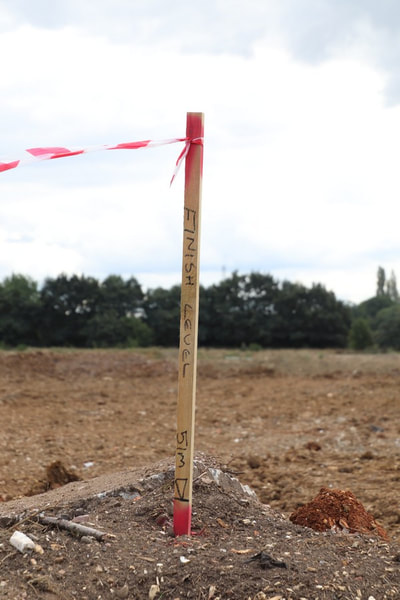
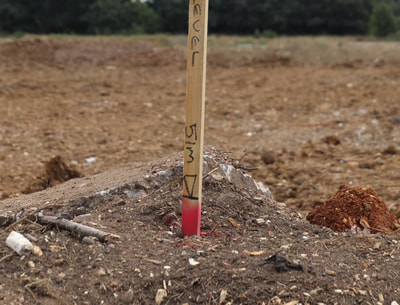
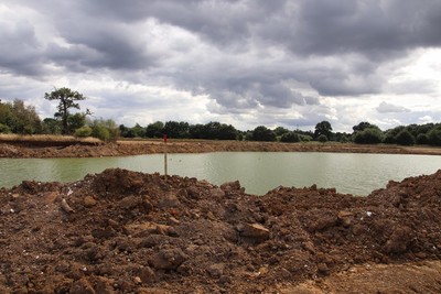
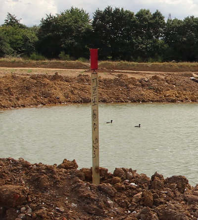
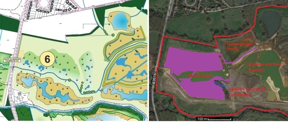
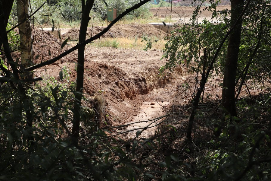
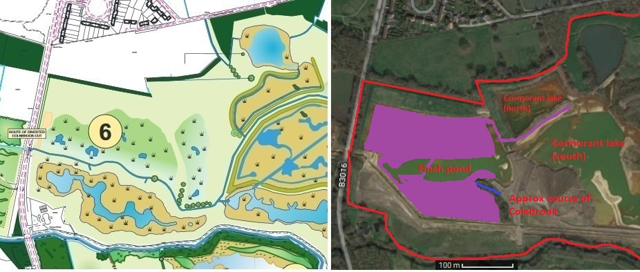
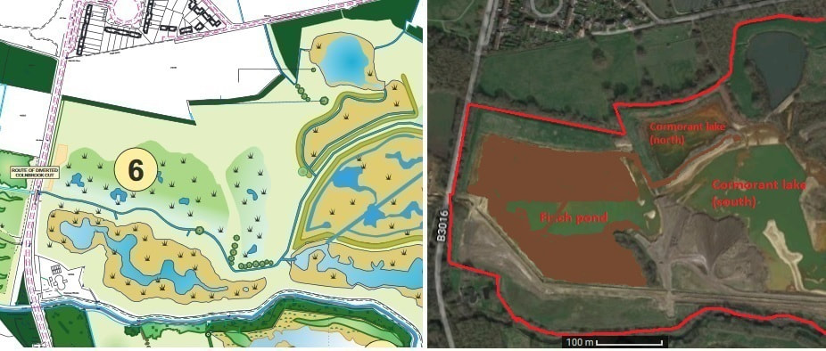
I was unable to get to Manor farm mid-week to see what was the current infill tactic. Instead I have to rely on memory as to what changes have taken place this last week. Firstly I immediately noticed a number of square poles, not unlike slender tree stakes, dotted about the site, each with a piece of red and white hazard warning tape fluttering from their tops. I couldn't decide if they were a new form of traffic control or survey marks (if that is the proper term). Most survey marks tend on construction sites tend to be in the shape of the cross of Lorain. Walking closer revealed that each had a red band, some 1"-2" (25-50mm) thick, about halfway down the stake, and one was on a pile of soil with the soil level with the band. Only when I was up close did I see the inscription "FINISH LEVEL", followed by a height in metres and a symbol i.e. a horizontal line level with the top of the red band on which rests an upside down triangle. When I got home and examined the photos, I noticed that some had the the triangle/line symbol (datum ?) on the top of the stake, and that the stake didn't have any red/white tape. These stakes were used where the infill was not yet high enough to have the symbol near the bottom of the stake. Obviously the land after infill has to be level with this mark. What I can't yet work out is if the height in metres is the depth of infill OR the resulting height of the land above sea level. I will consult my OS map, once I can find it. A quick research on t'internet suggests that Eversley Cross has a mean sea level of 60m. Finch Pond/Manor farm is a few metres above Eversley Cross. The two different types of stakes are shown in the gallery below. Judging by the stakes near the Longwater road entrance, the intention appears to be to raise the land to be almost level with the Longwater road at the entrance. This would certainly keep the proposed car park clear of all but the severest of flooding. To be fair, when the this area did flood earlier in the year, the water in Finch pond, Cormorant lake, etc didn't have anywhere to flow until Inert cut a channel to the culvert. Where upon the water flowed into Fleet Hill farm and caused flooding around the ponds there. However, the Blackwater breaches its banks there anyway. Inert have been piling up spoil during this past week to get the height of infill specified by these stakes. They have concentrated their efforts on the north east portion of Finch pond, building up quite a level of soil. Interestingly, they have left a large depression to the north west shore of Finch pond. It's sort of like an enormous sunken garden. Now, this could either be reed beds (i.e. a shallow area of the new, smaller, leaner Finch pond) or it might be the way I have seen Inert work in the past i.e. they build the edges of the subsequent infill before filling it all in. Time, as they say, will tell. They have also not taken the infill any closer to the ridge, but have simply continued to build up the eastern edge. Thus the pile of soil across the track to the cutting in the ridge is now the eastern edge of the infill, with a drop of about a metre. Though the track is now flooded as water levels continue to rise. I also noticed that work has been going on around the north side of the copse, particularly around the exit of the fragment of the Colebrook. I didn't investigate this part of the site this week or walk along the south footpath as I was busy with a family event. Finally, probably part of the surveying effort, I noticed a vehicle had been up the north embankment, and that there appears to be a curious lump of soil deposited on the west ridge next to the Longwater road entrance. This first slide show gives an indication of how much more the land will be built up around Finch pond. Remember that where I am standing, several metres of infill that has already taken place. On with the standard slide show. The five or so hours of rain we experienced on Thursday morning has resulted in the return of my old friend, the mud. Only in isolated places, mind, as the site is still largely bone dry and the soil rock hard. Unsurprisingly, where the mud does occur it is that fine, extremely soft and clinging variety. I had occasion to drive past the Longwater road at 19:30 on Wednesday evening. With no traffic on the road, I slowed as I passed the Longwater road entrance and glanced to my right to see if there was anything significant to be seen. Blow me if I didn't see the bulldozer driver working away on the north shore of Finch pond. Blimey, either he is putting in some serious overtime or there really is a big push on to complete restoration of the site. I have seen people working on the site on Saturdays, but this was very rare. You will not be surprised to learn, dear reader, that the infill of Finch pond continues apace. The main effort appears to be occurring on the north side, but it is difficult to work out what precisely is going on. There are many random piles of soil sprinkled about, some near the Longwater road entrance, others near the north embankment. It also appears as if the top surface of the area north of Finch pond has been scrapped off and pushed into said pond - much like what happened on the south shore area. However, it is hard to tell as there are obvious signs of a lot of lorry traffic. Some it, rather strangely, turning round by reversing into and then out of the Longwater road entrance. Most peculiar as there is a vast amount of turning space. The whole area is a rather complex series of trackways which the lorry drivers have to keep to - though the entrance to the track that leads to the cutting through the ridge has been blocked off. Again, a behaviour I have often seen during the restoration, to wit an area is worked on for a day or so then abandoned for several weeks or months. Moving swiftly on to the copse area. There are signs that the bulldozer driver has been working here. The track which wraps round the north of the copse and the area immediately east of it appears to have been extended into Finch pond. There is a lot of fresh soil, spilling into the pond via very steep sided banking. It is difficult to tell for sure (I was time pressured so didn't stomp on this part) as water levels continue to rise and the recent rain makes old bulldozed soil look fresh. However, I did notice that one of the huge heaps of soil around the boulder sorter outer (which appears to be still working away) was much depleted. Otherwise, our Thursday stomp along the south footpath revealed very few lorries trundling around. No doubts due to us walking around a little later than normal, but the number of lorries on the site does vary somewhat. This whole site is already a very important stop over point for many, many birds. Cormorant lake, particularly the post industrial wasteland, proves extremely popular. There are large flocks of Greylag geese, which I have recently learned to recognise, along with the usual hoard of Canada geese, Cormorants, Mallard, Gulls and Terns, etc, etc, etc. Swallows and Martins love the abundant insect life in and around the lakes, with large numbers congregating morning and evening. One particular surprise for me are the huge flocks of Lapwings. I estimate some of the flocks I see flying around to contain 60 or 100 individuals. They, in particular, love the open scrubby nature of the post industrial waste land, particularly the area I call the land mass, the scrape and Cormorant spit (before the latter gets flooded) and also the area I call the mud flats i.e. the east shore of Cormorant lake. What I found counter intuitive, was that once Finch pond was filled to a certain extent (about half its original size) and the landscape resembled the Somme the more birds it contained; aided and abetted by the numerous small islands that appeared. This in sharp contrast to the almost complete absence of birds when it was one huge lake. Many birds ignore the heavy plant trundling mere yards from where they are, though many wait for the quiet of evening to return. Except on Cormorant lake, where they cover the scrape, parts of the land mass and the mud flats. I think it's a shame that this post industrial open scrubby landscape will be 'restored' to yet another gentrified set of reed beds, dense woodland and ponds. We do have rather a lot of this generic nature reserve dotted around the area. Fleet Hill farm and Moor Green lakes being prime examples. I hope the big pipe on the mud flats is left. It floats when water levels rise to their normal levels, and often has up to 50 gulls and terns sat on it. Quite an amusing sight. I've tinkered with the progress map slightly, but still am unsure as to its accuracy. It doesn't matter hugely in the long run as the final result is what counts. It serves to give a flavour of how much effort Cemex and Inert put in to restoring this site. Now a slide show part II simply as many are shots from elevated positions i.e. either on the ridge, west embankment or atop a pile of spoil. As I review the shots in detail, something I do not always do, it reveals that my progress maps are really quite approximate. Roll on the final result! I thought I'd chuck in some wildlife pictures this week. Mostly I tend to put any wildlife photos onto the RSPB Wildlife forum as I am not sure how many people reading this blog would be interested in them. However, it is apparent to me how important this whole site has become for wildlife, both local and passing though. Well, dear reader, a lot has happened over the past week. It is difficult to decide where to start or imagine what I have missed. Water levels have risen considerably this last week, aided and abetted by the recent heavy rain. With the pump out of action and with more heavy rain forecast, I would not be surprised if water levels reach their normal levels in a couple of weeks. I wasn't able to get to the proto-reserve on Thursday. Instead I popped down early Friday morning; keeping to the south footpath due to heavy plant trundling around the site. Work was continuing apace on consolidating and extending the infill of the north shore of Finch pond. There were extensive piles of spoil all over the reclaimed land, quite evident from the south footpath. The bulldozer was hard at work, kept supplied by a fleet of lorries which this time, to my eyes, contained quite a few Inert haulage lorries. They appeared to out number the usual stalwarts: John Stacey. It is possible that this happened in the past, only I never noticed due to the infrequency of visits. I noticed that the erstwhile iron footbridge had been moved to block lorries turning left too soon after the works bridge. I could be wrong, but I feel that a rubble track has been laid near the works bridge. I'm sure this happened before, and it was all lifted and spread around various other tracks. In one of last week's photo of the west end of the north embankment, I noticed a dark patch of soil at its base. Quite obviously water was seeping out of the north embankment. I did wonder at the time if this would destabilise the soil. Inert or Cemex were of the same opinion, and so have cut a channel along the base of the north embankment to drain the seepage. The bulldozer had also scrapped a bit of the top of the east part of the north embankment. Just the top to remove nettle stubble. Very curious, and I'm not sure why. As expected, the contractors had returned to carry on strimming and mowing the rest of the north embankment and ridge; a short top and most sides was administered. Those side slopes are quite steep. I'm not sure if the men would walk up and down them to strim them. One method of dealing with steep slopes is to stand at the top, tie a rope to a mower, then let the mower go down the slope before hauling it up by the rope. I didn't walk the whole way east along the north embankment to see if the east ridge had been mown. It was lovely to be able to walk the length of the ridge without having to fight my way through chest high nettles. Shame this wasn't done three weeks ago. It would have saved me a lot of stings - particularly from the thistles. They are quite vicious when dry. Moving down to Finch pond. I'm a bit baffled as to why there were two rows of spoil. The bulldozer driver was quite precise in working between the two rows that I saw on Friday - most of which had disappeared by Saturday. There is probably a method to their madness. Infill and build up of Finch pond continued. There were a couple of deep holes in places. Not sure why or how they were formed. The little 'inlets' I postulated a couple of weeks ago that would be filled in have dutifully been filled in. Due to the wetness of late and the heavy lorry traffic, I noticed that some trackways had been beefed up with rubble from the boulder sorter outer. It, meanwhile, appears to be kept busy, judging by the huge piles of sorted spoil that still surround it. I am wondering about the south footpath. It has been mown and strimmed to a degree I can't say I've seen before. Perhaps it was done by the contractors who did the north embankment. If so, they also cleared a Willow tree that had fallen across the footpath in the recent gales. The only possible reason I see Cemex authorising this is that this footpath is due to be upgraded to a bridle path. I have no idea if Cemex are funding this. It may have been simple coincidence that the council came round to mow the south footpath at the same time the contractors were doing same to the north embankment. One small change I did notice took place near the Longwater road entrance. The area has been tidied up. There was a short low bank, that jutted out from the south end of the embankment running along the Longwater road. This has now been cleared. There were a lot of bulldozer tracks around this area. I have no doubts that much else has happened on Manor farm this last week, which I have not noticed or witnessed. The restoration is moving smartly along, though there is a lot to be done. Before the slide show, here is an example of what baffles me about the restoration process. Last year Inert cut a channel on the Hampshire side of the reserve. It ran parallel to the road leading to the works bridge, before emptying into the Blackwater. Every now and again it would dribble with water as it drained the Hampshire site. Two weeks ago, the memsahib noticed that the channel, which was quite small and narrow and had filled a bit, had been widened and deepened. This week she noticed that the channel had been filled in! Here is an image of the widened channel from a couple of weeks back. I didn't bother taking a photo of the filled in channel this week. No doubts there is some grand plan us mere mortals are unaware of. I also had a go at the progress map, as I was reasonably unhappy with my efforts thus far. I've made what I hope is a better stab at the extent of the infill and made it a nice lurid purple colour to stand out more. I've had an attempt at putting in the segment of Colebrook which was preserved (complete with wooden footbridge) in the copse. The progress map is very, very approximate. Yet another family event rears its head this weekend. Thus slide shows will appear as and when. We (the memsahib and I) popped by Manor farm on Tuesday as we had an errand down in Yateley. Inert were, as I suspected, off doing something I didn't expect. Firstly, the bulldozer driver was busily working on the south shore of Finch pond; merrily digging up the land that he had so nicely built up and smoothed earlier in the year. Large gouges had be scrapped and pushed into Finch pond. Secondly, a couple of contractors were hard at work strimming the chest to head high nettles and weeds on the east and north embankments; continuing the work they started a couple of weeks back. Saturday's early morning visit showed the top of the north embankment neatly trimmed all the way to the ridge. Part of the ridge had been strimmed, but, more importantly for me, a digger had neatly formed a ramp up to the ridge. It was quite uncanny for me to stroll along any part of the north embankment without having to fighting my way through nettles and weeds, and then amble up the ramp to the ridge; rather than having to engage in some mountaineering and 'climb' up a steep slope. Popping down for my jaunt on Thursday, we noticed that Inert had now switched to the north shore of Finch pond, and were (as expected) continuing the infill on that side of the pond. Saturday's extended visit revealed a vast amount of spoil, neatly piled up ready to either be levelled or pushed into the Finch pond. Walking eastward along the south footpath on Tuesday and Thursday, we noticed the usual plethora of haulage lorries (underpinned by John Stacey) trundling back and forth. Reaching the works bridge, I noticed that the pump was gone again. I'm not sure exactly when this happened. I'm sure it was there on Tuesday. This did happen last year, and like last year the pump had been getting a little noisier whilst chugging away. Possibly sent off for repairs or replacement? Needless to say, water levels in Finch pond and Cormorant lake had increased considerably. Even Cormorant lake north was looking a little soggy. Though there was the tiniest of trickle of water, if that, through the channel between Cormorant lakes north and south. I did wander down the gravel spit, separately the two afore mentioned lakes. Curiously, the bulldozer driver appears to have simple driven down to its east end, scraping the top surface of gravel as he went. Then dumped the scrapings off the east end of the spit, before trundling back west to the ridge. Very little had actually been done. It is all rather perplexing, but seems to be the normal modus operandi. No doubts the logic will be revealed as the weeks pass along. However, I feel the formation of the ramp up to the ridge and the cutting through the south end of the ridge do point to work commencing soon on dismantling the north embankment and ridge. We noticed a huge amount of activity on the Hampshire side of the site on the two days we walked along the south footpath. We mainly heard rather than saw the activity. I'm not terribly interested about this side of the site as most of it will be turned into a sporting complex. A quick squint as we crossed through the gates across the south footpath, seemed to show that the vast hole has been filled in and smoothed over. A channel that was cut last year, that lead into the Blackwater, has been deepened and widened. I did notice the tractor with water tank filling up said tank with water from a pond on the Hampshire side of the site. This small pond will form the only nature reserve part of the Hampshire site. Before the slide shows, a very approximate view of progress. I think the new north shore, as I have drawn it, should be further south - especially on the side nearest the Longwater road. The south shore should be a tad further south. If I redraw this progress map, I might use a colour that stands out more, i.e. black or purple or bright yellow. North and West embankments and the ridge I'm not sure why the north and west embankments were strimmed. In particular why the top and sides of the west embankment were strimmed, but only the top of the north embankment. Also, only a small part of the ridge was strimmed. Perhaps the contractors ran out of time. Rather curious if they did as they came around on Tuesday. Then again, this is what happened when they first visited the site: they only appeared to have strimmed the west facing slope of the west ridge. Whatever the reason for the strimming it does look as if Inert are preparing to tackle the embankments in the near future. A prediction which will probably be proved wrong. For the first time in a couple of months, I have revisited the gravel spit. Breeding season is now pretty much over with. Many birds are beginning to migrate. Inert have started work on the area. Cormorant lake and the gravel spit. It has been some weeks since I've been here. Both Inert and I have kept off this part of the site to allow birds to breed in peace. My greatest surprise (last week really when a cutting was made through the ridge) was how dry the area had become, due to a combination of pumping and drought. Anyway, enjoy the scenery as it is likely to change drastically over the coming weeks and months. Finch pond. Now back to the star of our show for the past few weeks. I was only half correct in sticking my neck out last week and saying that Inert would fill in the bit west of the causeway. They have, sort of, started to do this, and continue infilling the large area to the east of the causeway. What surprised me was that they worked on the south shore of Finch pond by dint of scraping off a couple of feet or so and pushing it to Finch pond. In addition, various lorry loads of soil were dumped on the area. It is just that this whole area was levelled and made smooth some weeks ago. I do find it quite an eerie feeling walking across the reclaimed land. I have been so used to it being an expanse of water. |
AuthorA polite notice first: All photographs on this blog are owned by me and subject to copyright. Archives
November 2025
Categories |
 RSS Feed