|
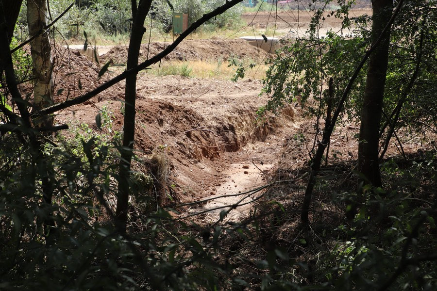
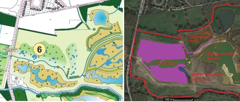
Well, dear reader, a lot has happened over the past week. It is difficult to decide where to start or imagine what I have missed. Water levels have risen considerably this last week, aided and abetted by the recent heavy rain. With the pump out of action and with more heavy rain forecast, I would not be surprised if water levels reach their normal levels in a couple of weeks. I wasn't able to get to the proto-reserve on Thursday. Instead I popped down early Friday morning; keeping to the south footpath due to heavy plant trundling around the site. Work was continuing apace on consolidating and extending the infill of the north shore of Finch pond. There were extensive piles of spoil all over the reclaimed land, quite evident from the south footpath. The bulldozer was hard at work, kept supplied by a fleet of lorries which this time, to my eyes, contained quite a few Inert haulage lorries. They appeared to out number the usual stalwarts: John Stacey. It is possible that this happened in the past, only I never noticed due to the infrequency of visits. I noticed that the erstwhile iron footbridge had been moved to block lorries turning left too soon after the works bridge. I could be wrong, but I feel that a rubble track has been laid near the works bridge. I'm sure this happened before, and it was all lifted and spread around various other tracks. In one of last week's photo of the west end of the north embankment, I noticed a dark patch of soil at its base. Quite obviously water was seeping out of the north embankment. I did wonder at the time if this would destabilise the soil. Inert or Cemex were of the same opinion, and so have cut a channel along the base of the north embankment to drain the seepage. The bulldozer had also scrapped a bit of the top of the east part of the north embankment. Just the top to remove nettle stubble. Very curious, and I'm not sure why. As expected, the contractors had returned to carry on strimming and mowing the rest of the north embankment and ridge; a short top and most sides was administered. Those side slopes are quite steep. I'm not sure if the men would walk up and down them to strim them. One method of dealing with steep slopes is to stand at the top, tie a rope to a mower, then let the mower go down the slope before hauling it up by the rope. I didn't walk the whole way east along the north embankment to see if the east ridge had been mown. It was lovely to be able to walk the length of the ridge without having to fight my way through chest high nettles. Shame this wasn't done three weeks ago. It would have saved me a lot of stings - particularly from the thistles. They are quite vicious when dry. Moving down to Finch pond. I'm a bit baffled as to why there were two rows of spoil. The bulldozer driver was quite precise in working between the two rows that I saw on Friday - most of which had disappeared by Saturday. There is probably a method to their madness. Infill and build up of Finch pond continued. There were a couple of deep holes in places. Not sure why or how they were formed. The little 'inlets' I postulated a couple of weeks ago that would be filled in have dutifully been filled in. Due to the wetness of late and the heavy lorry traffic, I noticed that some trackways had been beefed up with rubble from the boulder sorter outer. It, meanwhile, appears to be kept busy, judging by the huge piles of sorted spoil that still surround it. I am wondering about the south footpath. It has been mown and strimmed to a degree I can't say I've seen before. Perhaps it was done by the contractors who did the north embankment. If so, they also cleared a Willow tree that had fallen across the footpath in the recent gales. The only possible reason I see Cemex authorising this is that this footpath is due to be upgraded to a bridle path. I have no idea if Cemex are funding this. It may have been simple coincidence that the council came round to mow the south footpath at the same time the contractors were doing same to the north embankment. One small change I did notice took place near the Longwater road entrance. The area has been tidied up. There was a short low bank, that jutted out from the south end of the embankment running along the Longwater road. This has now been cleared. There were a lot of bulldozer tracks around this area. I have no doubts that much else has happened on Manor farm this last week, which I have not noticed or witnessed. The restoration is moving smartly along, though there is a lot to be done. Before the slide show, here is an example of what baffles me about the restoration process. Last year Inert cut a channel on the Hampshire side of the reserve. It ran parallel to the road leading to the works bridge, before emptying into the Blackwater. Every now and again it would dribble with water as it drained the Hampshire site. Two weeks ago, the memsahib noticed that the channel, which was quite small and narrow and had filled a bit, had been widened and deepened. This week she noticed that the channel had been filled in! Here is an image of the widened channel from a couple of weeks back. I didn't bother taking a photo of the filled in channel this week. No doubts there is some grand plan us mere mortals are unaware of. I also had a go at the progress map, as I was reasonably unhappy with my efforts thus far. I've made what I hope is a better stab at the extent of the infill and made it a nice lurid purple colour to stand out more. I've had an attempt at putting in the segment of Colebrook which was preserved (complete with wooden footbridge) in the copse. The progress map is very, very approximate. Comments are closed.
|
AuthorA polite notice first: All photographs on this blog are owned by me and subject to copyright. Archives
November 2025
Categories |


 RSS Feed