|
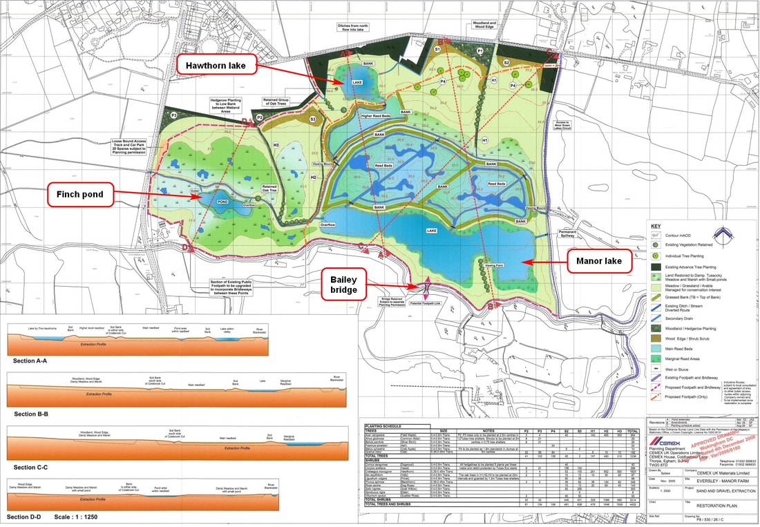
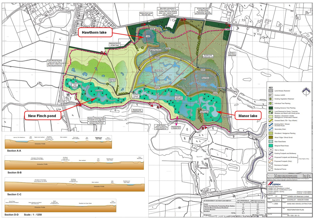
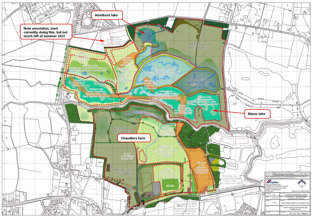
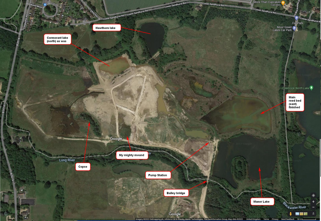
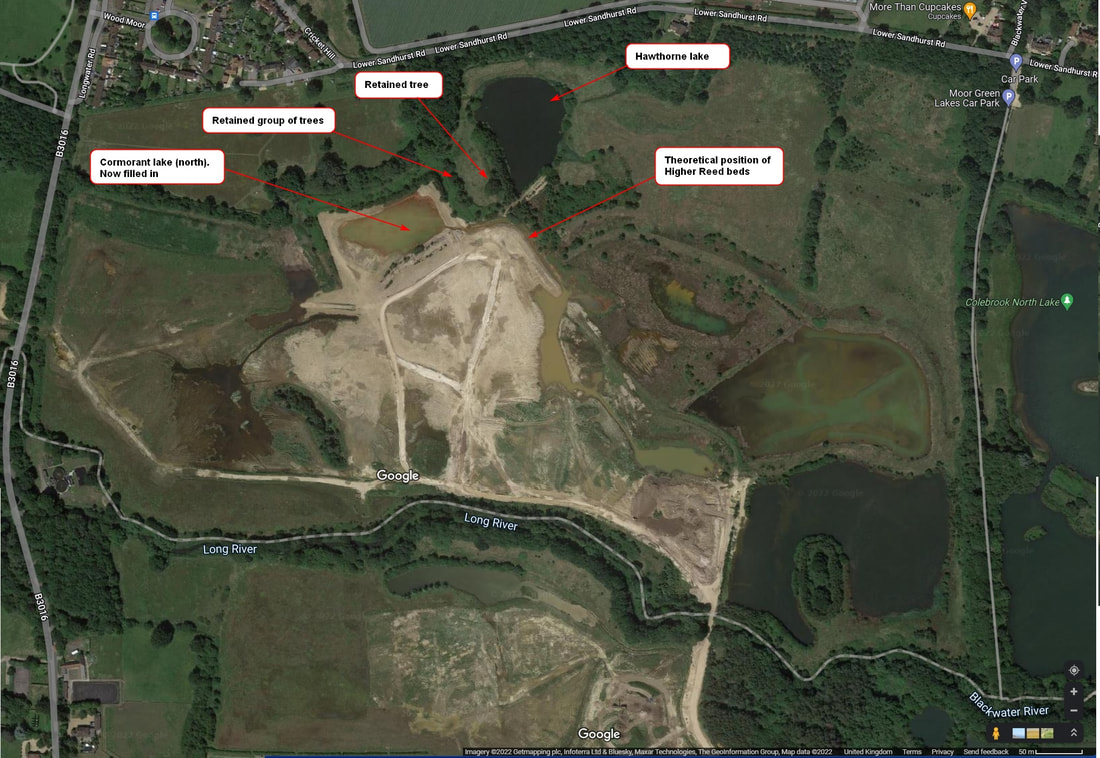
I have been saying, for quite some time, that the new elongated Manor lake will stretch from where it is currently all the way west to almost reach the copse. And it would be a lake, as in deep water, lots of it. Determined to prove my sanity, I went crawling over various planning applications on Wokingham Borough Planning website (which has a lousy search engine) and found this little beauty; the annotations in red boxes are mine. This plan was from 2005! Manor lake, as you can see, is one long lake. No wiggly bits, no extensive reed beds, etc. Also, note the size of the new Finch pond and Colebrook channel leading to Longwater road. Finch pond is quite small, while Colebrook channel is quite straight; exactly what Inert have been constructing over the past couple of months. Now fast forward to 2014. This is actually a plan which details Fully Restored areas of Manor Farm. Manor lake, although still long and thin, is now largely reed beds, with small areas of deep water. Finch pond is now long and thin. Inert, however, appear to be constructing a short, stubby pond similar to that in the plan above. Colebrook channel is still a bit wiggly - which is not what Inert have constructed. Their causeway is straight. Fast forward to March 2022, and we get this plan, showing fully restored areas. It isn't too different to the plan shown above; and it mainly details the restoration plan for this year. To confuse matters, it is also based on an older plan, which shows proposed extraction from Manor farm as restoration took place. What is interesting about this plan, is the area immediately to the south of Hawthorn lake. Compare it to the plan above, and you can see this plan says there is work still to be done, whilst the plan above says its complete. In both cases, I cannot reconcile the banking around Higher reed bed and Main reed bed plan with what I see being constructed on the ground. Finally, let us look at a Google Earth satellite photo from 2021.
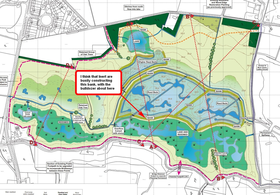
Firstly, the south shore of Hawthorn lake bears no resemblance to any of the plans. A bit strange this, as I have walked along this lake, and can assure readers that it is very complete, very mature, with a very nice piece of banking; well used by badgers, foxes, deer and other animals. Secondly, the east section of the Main reed beds conforms to the plans, including deeper areas. Thirdly, the east section of Manor lake does conform to the plans, and you can just make out the deeper areas. What is heartening about this lake is that it does appear to be quite deep. Though I when I talked to the Inert Site manager, he did say they were ordered to open sluice gates to lower water levels. Sigh, I like deep, big lakes, and so do wildlife. It is very popular with birds. This section covers the southern part of the site, principally Manor lake. I must admit to be disappointed at what Inert have a achieved this week. They seemed to be going like the clappers on Tuesday. I fully expected them to have completed the banking between Manor lake and the Main Reed beds. They hadn't made much progress since my Tuesday visit. There may be any number of reasons for this. They may have actually done a lot more than I realised e.g. spreading topsoil over most of the area, possibly fettling more than I could possibly appreciate. They may also have taken some leave, this week. It is a bank holiday weekend, with marvelous weather - not too hot or cold, no rain (depending on where you go), and the last hurrah before school starts. Work has been done. A line of spoil dumped awaiting bulldozing to form the banking between Manor lake and the Main reed bed. But I am hard pressed to figure what else, really. I know I sound like a stuck record, but I feel the mighty Finch pond and Cormorant lake should have been left as large, deep bodies of water, rather than being filled in. They can stand drought conditions far better than their shallow replacements. Predictions are that British summers will become drier and hotter, with the heatwaves we had this year being the norm. It is possible that there will be sufficient runoff from the Finchampstead Ridges to keep the new, shallow Finch pond and Manor lake topped up, but it would have been so much easier to have left Finch pond and Cormorant lake as they were. The area I called the Land mass, plus the land along the southern edge of the site, could have made excellent wetlands. On the other hand, plans for this site were drawn up a long time ago. Perhaps as much as 20 years. A lot has happened to the climate in that time. This section considers the east side of the banking built for the Main reed beds. I wish the designers had thought up better names that higher reed bed and Reed bed. I keep calling higher reed bed, upper reed bed. I've decided to call Reed bed, Main reed beds. After a long detour to get around a naughty little channel running along the west side of the Main reed bed banking, I walked up said banking and got more and more confused. The problem is, there should be two lines of banking, with a culvert/channel running between them. There is only one stretch of banking and, whilst the overall shape is correct, it and a channel that is already there, do not conform to the plans I have - unless said plans have changed. Anyway, Inert have continued to fettle this banking and have even started to build the banking between the Main reed bed and Manor lake. This section covers the area around the west side of Higher Reed bed and Main reed bed. Inert continue to transport topsoil from the western North embankment to smear it across the middle part of Manor farm. Oddly, the depth of soil looks quite shallow. However, there is still the ridge and eastern North embankment to be flattened. Some of the topsoil has been used to clearly mark out the western shore of Higher reed bed. I have a lot of problems reconciling what I see with what Inert have done when compared to the latest, alleged, plans I have from Wokingham Borough Council's planning website. This plan calls for Higher reed bed to be separated from the Main reed bed by two lines of banking, with a channel running between them. The issue I have is that I can only see one line of banking, which morphs itself from being part of the Main reed bed (the southern half) to being part of the Higher reed bed (the northern half). The western edge of the Higher reed bed should be surrounded by banking (there is none, currently) and its south west shape is both incorrect and insufficiently far south. There appears to be a channel in place ( I couldn't cross the thing, and had to make a long detour south), plus it's on the wrong side of the banking that Inert crafted over the past three weeks. On its southern edge, the channel is on the correct side of the banking. On its northern edge, it is not. Most peculiar. The south west corner of the Main reed bed, where is intersects Manor lake, is a bit of a complicated mess. Inert were working on this area, demolishing a former land bridge and using the spoil to create the banking between Manor lake and the Main reed bed. It all looks fine, and squares quite nicely with the plans I have, except that Manor lake does not extended far enough west, to my mind. Oh well, time will reveal all. It started to rain heavily at about 6:20am on Thursday. Not torrential rain, but a nice heavy, persistent rain, that had a fighting chance of soaking into the ground. I opened our back door and stood there, reveling in the rain and cool air. The rainfall continued for five hours. I reckon we got about 1 1/2 inches of rain. Wonderful. My poor, parched, dry, desert looking garden, with withered, brown plants, has bounced back. I actually got some runner beans! The affect on Manor farm was quite dramatic. Water everywhere. Finch pond was full. It had burst the little dam Inert had built, and was flowing down Colebrook channel and through the culvert under Longwater road. There was standing water, elsewhere. I was glad I donned wellingtons. I had to wade carefully along various tracks, where long, deep ruts had been formed by heavy plant. My nemesis on the south vehicle track, between the copse and my mighty mound, had returned, forcing me to wade gingerly around its edge. Other channels, to be part of the site's drainage systems, were also full of water, forcing me to take detours, particularly along the banking for the Main Reed bed. This site is going to be tricky to walk over, what with all the channels and banking, unless foot bridges have been planned to cross said channels. We start our four part update looking at the north west part of the site. No surprises there. Inert appear not to have touched the Finch pond complex. It is possible they may have smoothed off a couple of small heaps of soil, but nothing dramatic has changed. Sincere apologies to Inert if they have done a lot. They have, however, nibbled at the western north embankment. The western most chunk, which the digger was sat on during my Tuesday visit, is now gone. They have, for some obscure reason, due out a fair size crater on the former edge of the embankment. Also, the long line of spoil, neatly arranged south of the embankment has been partially flattened. It's all very peculiar. The going on the site was remarkably firm, given the five hour deluge we had on Thursday. I really expected the area to be quite boggy. Mid week special. Inert start building banking for north shore of Manor lake? 23rd August 202223/8/2022
Recently, my website activity figures have gone, well, crazy. Loads of hits on my blog. I can think of two explanations for this 1. People from various organisations are reading my blog. If so: wotcha. Hope you are enjoying the write up, and don't mind my sometimes pithy, sarcastic nature. 2. The hits are attributable to web bots and the like, sniffing my blog pages and gathering info. Can't even say "bugger off" to them, as they wont understand. I tootled down to Manor farm, today, as my swim wasn't until 12:30 - as opposed to the enforced summer schedule of 11:30. I arrived quite early, roughly 9:15am. Inert were busy on site. Two diggers, two bulldozers and two earth movers, all chugging away. One digger was perched precariously, to my mind, on top of the western North embankment, filling a heavy earth mover that had to reverse up a ramp to get close to the digger. There must be a very good reason for demolishing the embankment in this manner, but it does elude me. As I suspected, the heavy earth mover, once filled, trundles down the ramp and then across to the east side of current workings, to dump its top soil on an area south of the former Cormorant lake (north). A bulldozer then smears this topsoil over the area, while the heavy earth mover goes back for more stuff. I will be very intrigued to find out what happens to the Ridge and eastern North embankment, as I would have thought these would be a more sensible source of topsoil for this area. A second digger was merrily digging out what appears to be a land bridge, north of my (former) mighty mound. This stuff was being used to fill a heavy earth mover, which would then transport the spoil about 50 yards south, where it was dumped. Here, by my reckoning, a second bulldozer would then push this spoil to create an embankment. The course of this embankment looks suspiciously like that for the north shore of the new, elongated Manor lake. This would mark a major milestone for the restoration of the Manor farm portion of the Longwater road nature reserve; and it might, just might, mean that the site will be restored before the end of this year. YIPPEE! Whereupon, all the fiddly, fettling bits has to take place. Slideshow follows image Colebrook channel plumbed into culvert. Higher Reed bed being formed. Part 4. 20th August 202220/8/2022
This section covers Finch pond complex and the southern West Embankment. There's not a huge amount to be said. Inert have tinkered, dotting the I s and crossing the T s. Generally smoothing shorelines of Finch pond, smoothing the tops of mounds in the largest of the Finch ponds, continuing their flattening of the Southern West Embankment (but leaving a tiny bit) and clearing overgrown vegetation around footpath fencing. I still do not know what the structure Inert have constructed to the north of the channel is, apart from a welcome large pond, perhaps. I still have the feeling that Inert are either working loads of overtime (they were still on site at 16:15 on Friday evening, and my work Saturdays - though I get to the site at 6:00am so miss them if they do) or are now being paid for results i.e. complete a piece of work to get paid a fixed amount. Colebrook channel plumbed into culvert. Higher Reed bed being formed. Part 3. 20th August 202220/8/2022
This part covers what will be the Reed Beds and Manor lake. All I can work out here is that Inert are constructing something that is almost but not entirely like what is detailed in the latest plans I have. I can't be sure, because the whole area is a huge mess. What I think is going on is that in some areas Inert are bringing some material to to build structures with them e.g. embankments, clay capping, etc. In other places, much as I predicted, Inert are engaged in digging stuff out after over filling the area e.g. Manor lake. Granted, a large proportion of this area will be shallow reed beds, but still, I did say. The deeper part of Manor lake will definitely need digging out. I do feel that events will proceed quickly around the reed beds and Manor lake as there isn't a great deal of constructing that needs doing. Well not on the scale of the infill. However, demolishing the land bridges might take time and till require a lot of planning so as not to cause heavy plant problems with the rains finally arrive. Colebrook channel plumbed into culvert. Higher Reed bed being formed. Part 2. 20th August 202220/8/2022
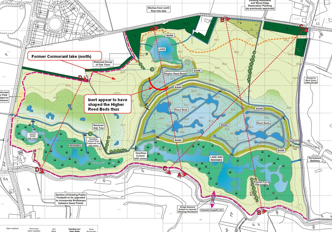
Right, dear reader, this is where it gets weird. This section covers what I think is going to be the new Higher Reed bed. I say 'think' because I cannot readily reconcile the latest plans I have from Wokingham Borough Council's (WBC) planning department against both what Inert are actually doing, and Google earth satellite imagery. Let's start with the latest plans I have from WBC's planning dept. The Higher Reed Bed is a slightly distorted kidney shaped structure, south of Hawthorne lake, and north west of the much larger Reed Beds. Also note how the Higher Reed Bed is almost completely surrounded by banking. Now examine the latest Google earth satellite image I have Ignoring the fact that the satellite image is old, and that Inert have done a huge amount to the site (e.g. Cormorant lake (north) has now been filled in) you may note that Hawthorne lake (the north most lake) have different shapes. I do not think that Inert will be called upon to reshape this lake; but you never know. This lake is now quite established, it has a robust bit of banking to its south, and I have seen another set of plans which indicate that restoration is complete around Hawthorne lake. Now on to what Inert are up to. They are sort of following the latest plans I have but not quite. The first point to note is that the Higher Reed Bed does not extend far enough westward or, I think, southward. The kidney shape has been truncated. I've tried to indicate this on the plans. The second point to note is that that east side of the banking that surrounds the Higher Reed Bed does not turn northward via a right angle bend. In the grand scheme of things, I don't think this really matters. What does matter is that we end up with a reed bed that is pretty much on the same size and shape as that on the plans. Suffice it to say, after upfilling this area, Inert are now digging it out to form the Higher Reed Beds, and surrounding the area with a solid, wide piece of embankment. I'd be intrigued when they put the sluice gates in. Colebrook channel plumbed into culvert. Higher Reed bed being formed. Part 1. 20th August 202220/8/2022
I must admit I swore a little when I visited Manor farm on Thursday morning and thought Inert had not achieved very much. They appeared to have begun back sliding to their old habits of a flush of activity followed my months of slow, glacial progress. Some more of the southern West Embankment had been removed, along with overgrown vegetation. This gave a view over the site not seen for decades. Inert (two bulldozers, one digger and one heavy earth mover) were not doing anything. All was quiet. Round about 10:00, two plant operators clambered into the cab of the heavy earth mover (fully loaded with spoil), and the driver drove them to Chandlers farm. I was not expecting much when I visited the site early Saturday morning. Was I in for a surprise. This part details the Colebrook channel, western north embankment and what was Cormorant lake (north). But firstly. We had some rain! Actual rain. It fell on Monday and Tuesday. Unfortunately we didn't get very much in Finchampstead. However, indications are that Manor farm and surrounds south of The Finchampstead Ridges, received a fair amount of the wet stuff. Standing water here and there, ground getting soft, with tracks being chewed up by heavy plant make deep ruts. My nemesis, mud, is back, particularly on one section of the south vehicle track. Inert have been demolishing land bridges. I should have noticed earlier, and I did wonder what they were going to do with them. Well, their flattening them, and appear to be taking the spoil beck over to Chandlers farm. The channel, which Inert have been crafting to contain the reinstated Colebrook, has been plumbed into the culvert that runs under the Longwater road. This culvert used to contain a conveyor belt, which took gravel from Fleet Hill farm (after crushing it), across Manor farm, over the river Blackwater to Chandlers farm for processing and dispatch. Water could flow from Manor farm to Fleet Hill farm, if Finch pond had any decent depth of water and was itself connected to the Colebrook, way over in the east. What does confuse me about the plumbing is there is quiet a complicated bend in the channel where it reaches the culvert. More of the western north embankment has been removed, but not as much as had expected. This simply reflects Inert's standard method of flitting all over the site. Again, of great perplexity to me, is the capping of what was Cormorant lake (north) with topsoil. My perplexity - Inert have not used topsoil from the eastern north embankment or ridge. They've trundled the stuff in from the west embankments! The reason for this eludes me, as it is time consuming and burns up lots of derv. |
AuthorA polite notice first: All photographs on this blog are owned by me and subject to copyright. Archives
November 2025
Categories |
 RSS Feed