|
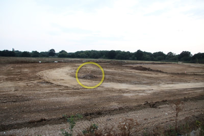
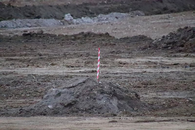
There is a danger, dear reader, that updates are going to be a little repetitive over the next few months. As suspected, Inert appear to now be concentrating on raising the level of infill to the survey marks. That being said, they do appear to be bopping all over place. There are signs of considerable work on both north and south shores of Finch pond, plus activity in and around the pump station, and the ever changing piles around the boulder sorter outer seem to keep growing. The area I presumed to be a scrape is now back to being an isolated scrape, due to the pump still being absent. Other areas around Finch pond are now well and truly underwater. To wit, the track leading to the ridge cutting, and the track around the north end of the copse. The 'causeway' going across the middle of Finch pond had long disappeared under the waves. Looking at how Inert are raising the level of land, I am wondering if the level of the eastern portion is at its proper height for the base of the infill, and that it will be capped by soil from the north embankment. Consider these two photos. The left photo shows a portion of the eastern infill. The circle is where the mound in the right photo is located. The base of the red and white warning tape is the target height of the land. Now seeing as the land will be capped with inert soil, one can suppose that the level of rubble filled spoil has been reached (i.e. the base layer) and that the north embankment will be bulldozed to achieve the final land level. That is my guess, but as I have seen over the past year or so, my guesses have this habit of being way off the mark. I am quite intrigued what is going on around the pump station and works bridge. Some of the activity is due to traffic control. The bulldozer drive builds up banks of soil to mark the edges of tracks the lorries have to follow. Some of the activity I am not sure about. The land does have to be built up, but intriguingly the track of crushed rock continues to grow, and is nicely sculpted. Two slide shows today. The first is my lunchtime walk along the south footpath on Friday. The second is my visit on Friday evening to photograph progress with in the site. It was late evening, and the sun had just set, so it was very gloomy. I have had to process all the photos to try and increase light levels. This has made some of the photos look quite surreal. Now onto the photos from my internal, late evening walk. For any readers new to this blog, I must continue to remind people that I have permission to be on this site. It is not a public space. Comments are closed.
|
AuthorA polite notice first: All photographs on this blog are owned by me and subject to copyright. Archives
November 2025
Categories |


 RSS Feed