|
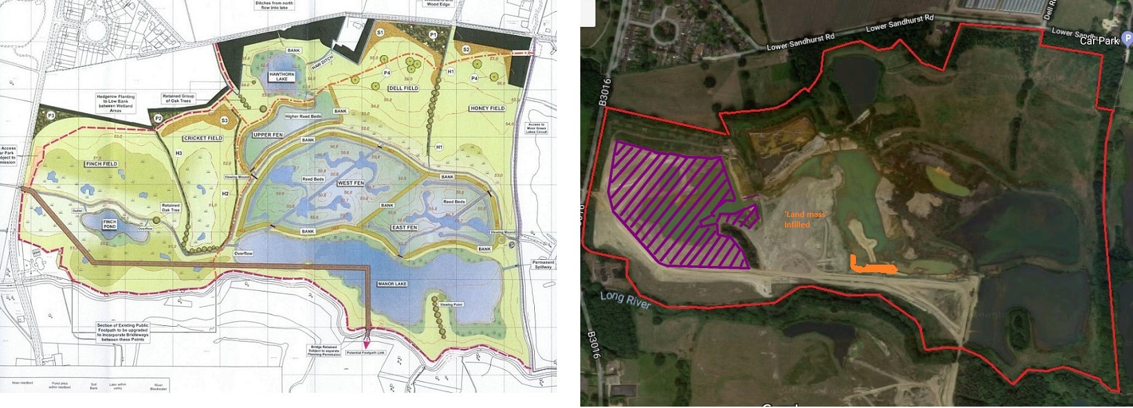
I fully expect all restoration efforts to cease for a minimum of a week if not two as various construction and quarry staff take a well earned rest. Most builders tend to shove off for a couple of weeks over Christmas. However, we are in the age of working all hours given to us in pursuit of the mighty dollar or, in some cases, stupid deadlines dreamt up by some numptie in management. Restoration efforts appear now to be centred on the south shore of Cormorant lake. Only one bulldozer was in evidence, on my Wednesday stomp, chugging up and down the shoreline of Cormorant lake. Various tipper and grab loader lorries were delivering inert waste. Part of the banking that used to run the length of the south shore of Cormorant lake (south), built for traffic control (i.e. stopping plant from driving into said lake), has now been bulldozed away into the lake. It must now be fairly dangerous. The pump has stopped, which means water levels are high. Recent (and continuing) heavy rains has turned the whole area into a quagmire. To the point where I refuse to walk on certain parts (e.g. area west of copse, latest infill into Cormorant lake) as the quicksand like mud was so deep. All vehicles were driving very carefully. Even my normal trick of keeping to the bulldozer tracks doesn't always work well. The new bulldozer has wider tracks, which means its surface pressure is much less, resulting in less soil compaction than its predecessor. Where possible, I follow the lorry tracks as they compact the ground more. I am a little perplexed (who isn't) with the latest infill. Plans seem to indicate that the south shoreline of the new combined Cormorant/Manor lake will pass quite close to the south footpath. Perhaps even closer than now, offering superb viewing of wildfowl; provided a whole load of trees aren't planted to obsure the scenery. However, the infill seems to be pushing the south shore further north. Now, this might simply be due to the way Inert work. They seem to build up the infill, then bulldoze it down, before building up again, only to then dig it out to the final contours. Time will tell, but it does seem a shame to fill in such a nice, well used deep, large lake which already works well to attract all forms of wildlife, as well as keeping viewers happy. I can't tell if more work was done on Finch pond just north of the copse. As I've commented before, one muddy patch of infill can look pretty much the same from week to week. One trick I have of establishing if work has been done or not is to see if my tracks, from the previous week's walk, are still visible. It's not foolproof, but if they have disappeared then there is a fair chance the bulldozer erased them I clambered to the top of the pile of sorted spoil to take a 360 of the area. I am not sure why I never thought of doing this before - perhaps due to me keeping clear of the area during the breeding season. Anyway, after checking that the heap was well consolidated, I clambered to the top of it. What a mighty view it was. I always maintain that some raised viewing platforms should be built on nature reserves. It gives a completely different perspective. Wildfowl, not surprisingly, were a little sparse on Cormorant lake. I think the Teal, which flew in a week or so ago, were still there in large numbers. I say I think, as my bird recognition skills are not that good, and Saturday was too manky a morning to be taking good photos to aid in recognition. I've done a new progress map to now take in Cormorant lake. It gives an idea of how much work there is still to go. Only a year lads. No pressure. I've marked out, to the best of my dodgy estimating ability, the amount that Finch pond (purple) and now Cormorant lake have been filled in. As I've used the latest google earth image, you will notice that it shows bits of Finch pond already filled in. Also the area I have been calling 'the land mass' is infill. Comments are closed.
|
AuthorA polite notice first: All photographs on this blog are owned by me and subject to copyright. Archives
November 2025
Categories |

 RSS Feed