|
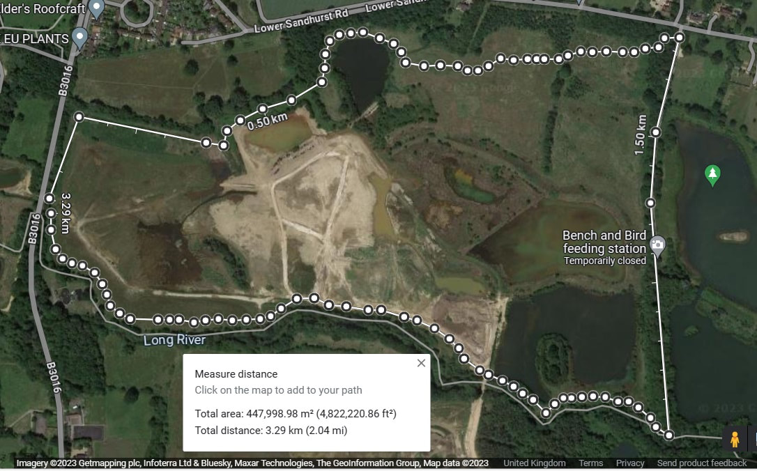
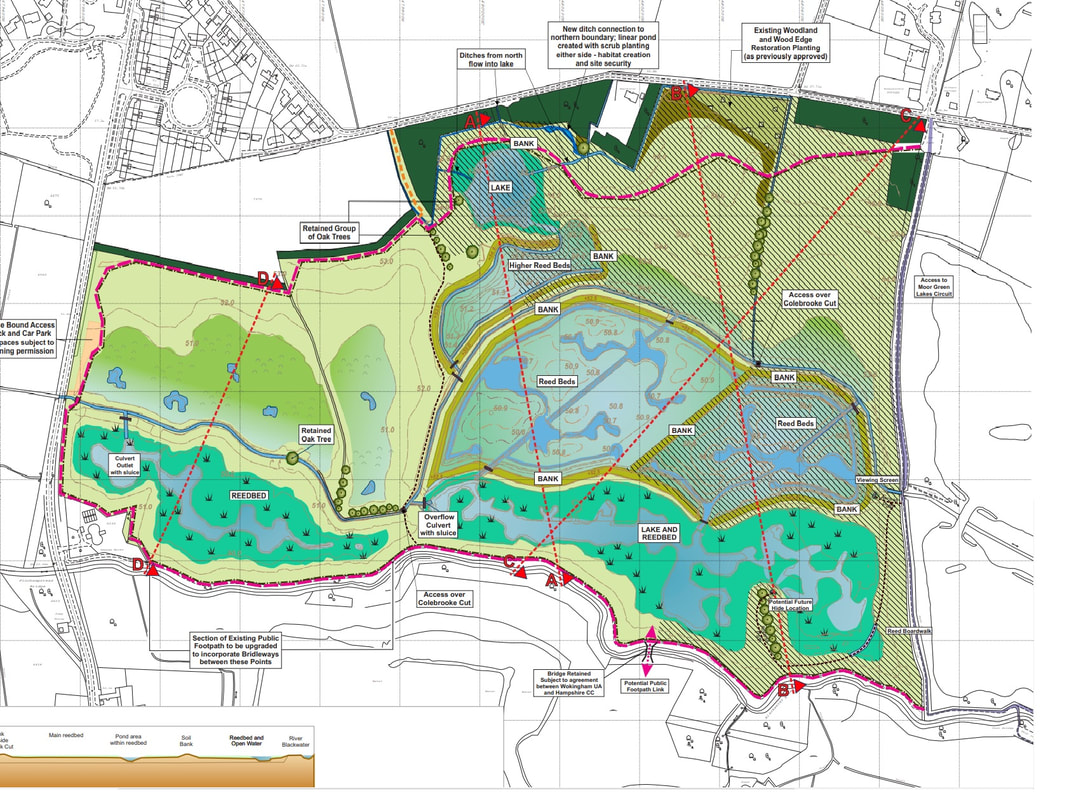
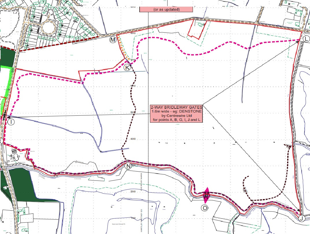
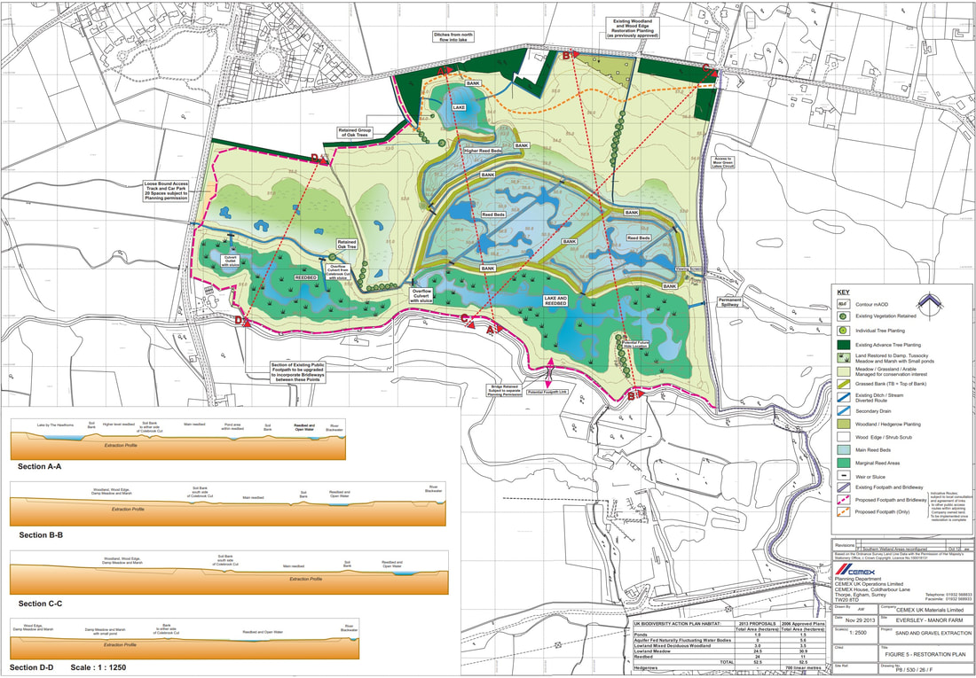
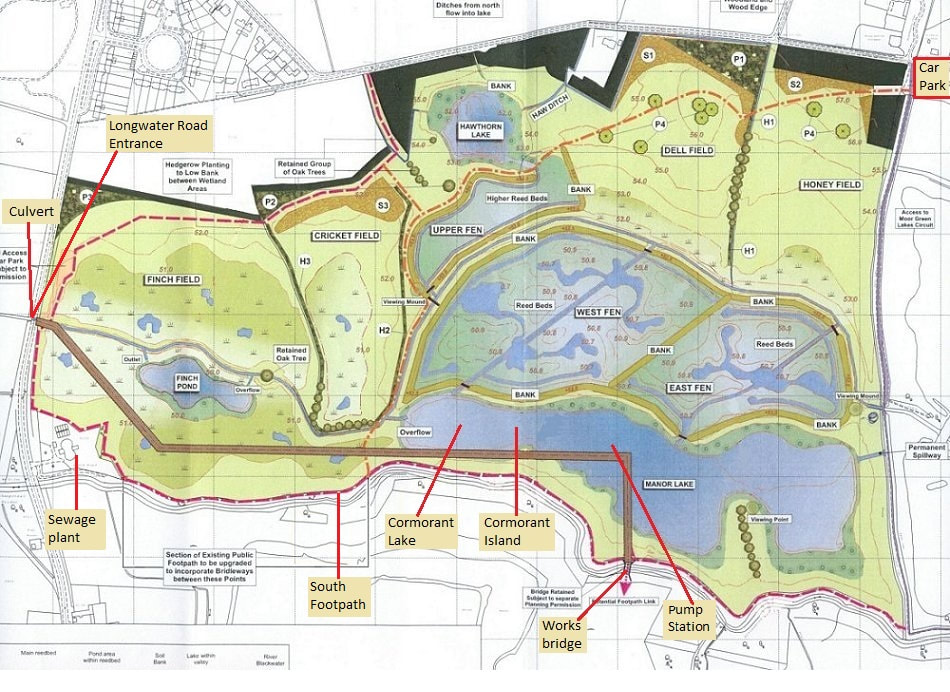
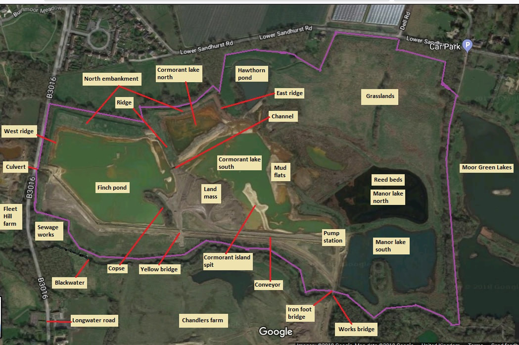
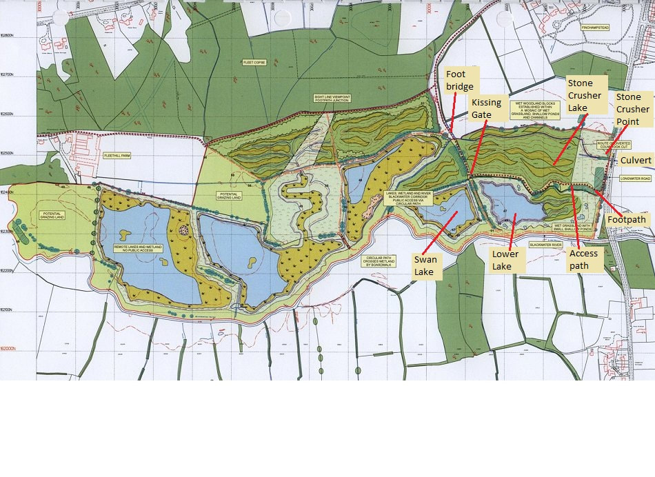
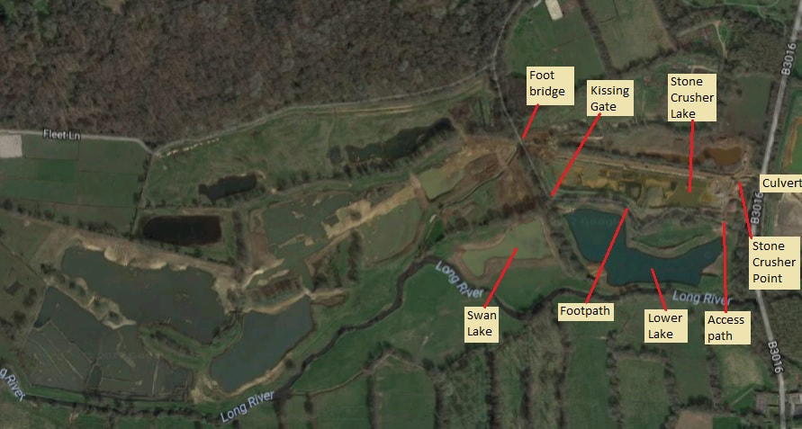
Regulars of this blog might have noticed a change in its name. The Finchampstead Neighbourhood Development Plan have given it a name: Longwater Road Nature Reserve. Notification: I must point out that I have special permission to be on the Eversley quarry site of Fleet hill farm, Manor farm and the Hampshire part, Chandlers farm. These are not open areas for general access. Public rights of way are being incorporated into the sites to enable people to enjoy the new reserves. Please bear this in mind. Although I refer them in my blog as reserves, they are still, technically, part of an operating quarry. So please keep to the existing public rights of way, and wait for the new ones to be adopted. Also it is will be even more important to stick to the public rights of way when they do become reserves so as not to disturb the wildlife. Update: Apparently Cemex and RSPB have been working together to restore 1000 hectares of ex-gravel works to prime habitat. The aim was to achieve this by 2020. They actually managed the 1000th hectare in 2017. Eversley was the first hectare to be restored under this partnership; actually the Moor Green lakes and surrounding area e.g. Horseshoe lake. This youtube video features scenes from Manor farm which regular readers will be familiar with. Here is an explanation on the RSPB's website, and here is one on the Cemex website about them being runner up in the MPA Quarries from Nature awards due to their work on the Eversley quarry restoration. 27th Jan 2018 - we get a mention in The Telegraph: 50 disused quarries turned into wildlife habitats to help Britain's endangered wildlife. "Eversley Quarry in Hampshire was the first to be completed following three years of work by wildlife and conservation experts." Ahhh, they missed phase 2, the subject of this blog. This blog is about a proposed nature reserve on the Cemex gravel extraction works between Finchampstead and Eversley. There are three parts to the reserves. 1. Moor Green Lakes. This reserve already exists. It was restored by Cemex some years ago. 2. Manor Farm. Eastern half of Longwater Road Nature Reserve. 3. Fleet Hill Farm. Western half of Longwater Road Nature Reserve. Initially, this blog concentrates on the restoration efforts Cemex engaged in prior to handing over the reserve to a conservation group for day to day management. Once this happens, I would then hope to chart the efforts required to turn the raw restoration into a fully operational nature reserve. That being said, there is already a wealth of wildlife inhabiting the site, mostly as Cemex have ceased extracting gravel, and appears to be a mecca for bird watchers. We often encounter them as we walk around the footpath, humping their tripods, spotting scopes, cameras and binoculars or perhaps exchanging notes with each other on what they have spotted that day. Although I live about three miles away from the proposed new reserve, I only learnt about it recently. I started to photograph the efforts Cemex are expanding in clearing the gravel works and, as is the nature of such endeavours, realised I had a photo journal before I knew it. Update 25th October 2023. Bridlepath walk is roughly 2 miles. For the past few weeks, Inert have been constructing bridlepaths around most of Manor farm restoration. Last Sunday morning, between 7.30am and 8.20am, I walked a circular route around these new bridlepaths and the existing bridlepath between Lower Sandhurst road and the river Blackwater. I was taking lots of photographs along the way. I might be the first person to do this. According to the measure distance tool on google maps, the distance is a little over 2 miles. Some of the views are spectacular, and will only improve as the nature reserve matures. Construction of the bridlepaths is a truly momentous occasion as it signifies that the restoration is almost complete. Cemex assure me, and others, that this will occur before year's end - well, the landscaping at least. There may be frilly bits like planting trees, reeds, building a car park, etc. Extent of entire reserve The plan below shows the extent of the reserves. It stretches for 2.2 miles along the Blackwater river. Moor Green Farm is already a nature reserve, namely Moor Green Lakes nature reserve. For more details see here Moor Green Lakes Group or here RSPB entry. The Moor Green Lakes Group may or may not merge with whomever manages Longwater Road Nature Reserve. It is unlikely that the MGLG will manage Longwater Road Nature Reserve as it is just too big for this tiny group. Perhaps you could join us on one of our work parties to aid in the conservation of Moor Green Lakes? Fleet Hill farm is supposed to be ready as a reserve by end of summer 2017. Apart from a few sub-phases, this appears to have been achieved. Approximately 18 months later, Manor Farm will be incorporated into the reserve. A target date in a planning application I read suggested that restoration of Manor farm should be completed by 31st December 2018. Personally, as of 7th October 2018, I can't see this happening unless the scale of infill is altered drastically or a lot more resources are thrown at the restoration effort. At times of writing, it is February 2023. Inert are infilling the current Manor lake, which will take them all of 2023 at the least. You may notice, dear reader, quite a few differences between the various plans and google earth images of the reserve displayed below. I am not sure why. I suspect that some of the differences are due to extraction of gravel. This is certainly true of the Fleet Hill farm portion of the reserve. Note: I have since discovered that the plans for the restoration were fairly fluid and subject to numerous alterations. Update: I am keeping my speculations for historical reasons. Part of the 'fun' of keeping this blog is working out what Cemex and Inert are up to. Well, the later posts show that they are infilling Finch pond. They may also modify Cormorant and Manor farm lakes to look more like the plan. Plan of proposed Manor Farm part of reserve and image from Google Earth NOTE: I've finally got around to updating the google earth image with the expanded reference points. Hopefully, this will allow you to navigate my text a little better. The plan below is the Manor Farm extension. Below that is a Google Earth image as of March 2017. Note the difference between the it and the plan. Particularly Finch Lake, which is now huge, and what I have been calling Cormorant Lake which is supposed to be joined to the bigger lake to its right. The Pump Station area, currently on dry land, would be in the middle of a lake, according to the Cemex plan. As described above we start our walk at the Moor Green Lake car park, located in the top right hand corner of the map. The details shown in this map are the proposed public right of ways, and possibly some further landscaping. As an example, currently there is a sizable lake at the point I call the Pump Station. This lake is not shown in the map. There are large areas of this new reserve I have not photographed as we have tended to keep to the current public footpaths. We cross the Longwater road at the culvert/entrance to the reserve to get enter Fleet Hill farm immediately opposite. Update: February 2023: WBC's Planning website appears to have been updated with revised documents. As we approach the end of landscaping (ground works) I have realised the problems I have had with plans supplied on WBC's planning department website. The draughts person has used the originals, but not updated them correctly. One glaring discrepancy is the double banking between the upper and main reed beds. This is now been built as a single bit of banking. The shape of Finch pond south is not as built, and the plans do not show Finch pond north. The legend is particularly bad in places. Looking at Manor lake, the legend suggests that this will be an area of damp, tussocky, meadow land. However, the colour of the plans would suggest reed beds. This latter assertion is reinforced by the labelling on the plans, which says reedbed! I am singularly unimpressed by the hide on the north end of the peninsular being a proposed hide. Placing a hide and screens here (with views west, north and east) should, in my view, be top priority. The Longwater road nature reserve has been billed as an amenity for Wokingham council residents - not a private reserve for a select few. There should be a balance struck between protecting and nurturing nature, whilst providing mindfulness, viewing and learning opportunities for the council's residents. Update: January 2023. This is the proposed rights of way for Manor farm. Horse riders appear to have a very powerful lobby group, and are extracting a great deal of concessions from Cemex. Ver little appears to be being done for pedestrians or cyclists; though the latter will use footpaths and bridlepaths. However, looking at these plans it appears that the existing Blackwater footpath (aka south footpath) will be retained and be separate from the bridlepath that is proposed to run inside Manor farm. I find this very odd, as the horse riders, being so high up, will cause more disturbance for wildlife than pedestrians or cyclists. The bridlepaths around Moor Green Lakes are well screened by trees. Potentially the most exciting path is the one running through the middle of Manor farm. This will give better views of the lakes and reed beds than simply having one path around the perimeter of the site. Unfortunately, it is a permissive footpath, which gives no rights to pedestrians to use it, and use of the footpath can be revoked at any time, without reason. The other odd footpath (again permissive) is the one running around the southeast side of the site. This should give good views over Manor lake - except this vista will be obscured by tall reed beds. Go to Leighton Moss for a good example of this. Update: Oct 2022. The plan below is the only one I have been able to find on the Wokingham Borough Council Planning website. It has hardly changed over the years, even though it is billed as being the most up to date. However, as I record the restoration since March 2022, I realise that these plans are approximately accurate. There are a number of differences. 1. Finch pond now consists of two parts: North and South, separated by the Colebrook. The Colebrook now flows in a wide, straight channel - not the wiggly one show in the plans. Also, unless Inert create them in the next few weeks, the small lakes around the new Finch pond do not exist. 2. Copse. To date, the copse still exists. It has not been flattened - fantastic! 3. The final layout of Cricket hill (see second, older plan) appears a little fluid, and does not follow what is in the plans. The boggy area at the south end of Cricket field has been created. However there also appears to be a new boggy area to its north. 4. Higher reed bed only has a bank along its east and south east sides. There is only one bank, not the double bank shown in the plans. The banking along the South east side is shared with the main reed beds. A channel runs along the east bank and south east bank to the south side of the site. 5. The main reed bed banking is still under construction as I type this. The south edge of this bank sort of conforms to that shown in the plan. These are the plans for Manor farm which were available when I first started this blog. Whilst the overall structure of the site remains largely static, there are a number of significant changes. The most startling change is that Manor lake will no longer be a large expanse of water. Minor modifications occur with Finch pond (it has got larger, its shape has changed, and it has gained a twin to the north of Colebrook) and the banking around the fens. Plan of proposed Fleet Hill farm part of the reserve and image from Google Earth. This is the Fleet Hill farm extension showing proposed structure and public right of ways. Below that is a Google Earth as of Sept 2017. Stone Crusher lake is a small manky green lake. The plans below suggest that it will be filled in. Swan lake is also a small manky green lake, which according to the plan will get bigger. There is a large part of this extension that I have not really photographed as we have tended to stick to the footpaths. Most all the restoration had been completed by the time I started photographing the works. Update: Oct 2022. I have photographed all of Fleet Hill farm and presented them in their own post. Update 7th October 2018. I suspect that apart from a few small pieces of work (e.g. completion of bridle path) Fleet Hill farm is pretty much restored. One of the planning applications I read said that tree planting will occur in the year after restoration has been completed. As this happened earlier on in 2018, this would suggest that, apart from a few sub-phases, restoration is complete. Update: Oct 2022. Fleet Hill farm is pretty much a reserve now. It has been some time since I visited it, as all my efforts have been concentrated on Manor farm restoration. Comments are closed.
|
AuthorA polite notice first: All photographs on this blog are owned by me and subject to copyright. Archives
November 2025
Categories |

 RSS Feed